
Upper Dounreay


Standing Stone (Prehistoric)
Site Name Upper Dounreay
Classification Standing Stone (Prehistoric)
Canmore ID 7841
Site Number ND06NW 2
NGR ND 0062 6607
Datum OSGB36 - NGR
Permalink http://canmore.org.uk/site/7841


- Council Highland
- Parish Reay
- Former Region Highland
- Former District Caithness
- Former County Caithness
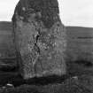
ND06NW 2 0062 6607.
(ND 0062 6607) Standing Stone (NR)
OS 6" map, Caithness, 2nd ed., (1907)
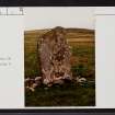
This upright slab of sandstone, facing ESE and WNW, slighty pointed at the upper end, is 6ft 6ins high above ground, 4ft 2ins broad and 1ft thick.
RCAHMS 1911.
As described above.
Resurveyed at 1:2500.
Visited by OS (N K B) 23 November 1964.
No change to the previous field report.
Visited by OS (J B) 7 September 1981.

