
Wilsontown


Public House (19th Century), Storehouse (19th Century)(Possible)
Site Name Wilsontown
Classification Public House (19th Century), Storehouse (19th Century)(Possible)
Alternative Name(s) Wilsontown Ironworks
Canmore ID 99532
Site Number NS95SE 11.09
NGR NS 9507 5526
Datum OSGB36 - NGR
Permalink http://canmore.org.uk/site/99532


- Council South Lanarkshire
- Parish Carnwath
- Former Region Strathclyde
- Former District Clydesdale
- Former County Lanarkshire
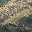
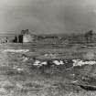
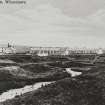
2 storey 3 bay house in coursed rubble with plain skews and surrounds to its openings. The pitched roof is in slate, whilst a detached row of roofless outbuildings stands to the left.
Used at various times as a store, shop and a public house, with the remains of two ranges of outhouses to either side, forming a courtyard. These buildings are all depicted on an 1826 map of the Wilsontown Estate, and all three are still roofed on the 2nd edition of the OS 25-inch map. This site has been identified as Wilsontown Store, which was built in 1808, Forrest's 1816 map of Lanarkshire, however, identifies it as an inn, and it is shown as a public house on the 1959 edition of the OS 1:2500 map. (RCAHMS)
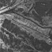
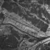
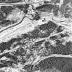
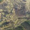
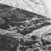
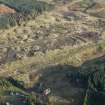
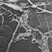
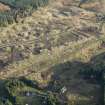
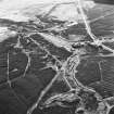
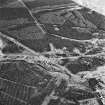
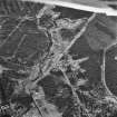
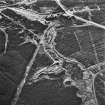
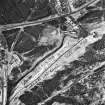
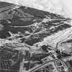
Wilsontown was the second coke-fired ironworks in Scotland, and the first ironworks in Lanarkshire. Started by three brothers, Robert, John and William Wilson, the business later passed into the hands of William Dixon, who managed the works until it closed in 1842, the area then being coal mined until 1955 when the site was acquired for forestry use. At one point the village was populated by 2000 people. (Forestry Commission Scotland)
Field Visit (October 1994)
NS95SE 11.09 9507 5526
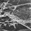
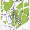
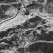
At the N end of Wilsontown Ironworks (NS95SE 11.01) there is a roofed building, used at various times as a store, shop and a public house, with the remains of two ranges of outhouses to either side, forming a courtyard. The principal building (CSW 1030, NS 9507 5526) has two storeys and an attic, with an external stair on the ESE side. Although roofed, it has been unoccupied for a considerable period, the interior has been gutted and the windows have been sealed up. The building forming the S side of the courtyard has been demolished, and an area of disturbed ground marks its position, but the N range of the courtyard is better preserved, comprising a rectangular building 16m in length by 6.1m in breadth over mortared-rubble walls 0.6m thick (CSW 1034). It is roofless, but the gables are complete. There has been an outshot on its ESE end, and there is a porch on the SSW side. It has two compartments, that to the E having a wide door.
These buildings are all depicted on an 1826 map of the Wilsontown Estate (National Library of Scotland, Map Library, ref.no. EMS.P.166)), and all three are still roofed on the 2nd edition of the OS 25-inch map (Lanarkshire 1897, sheet xx.2). This site has been identified as Wilsontown Store, which was built in 1808 (Smith 1985 and pers. comm.). Forrest's 1816 map of Lanarkshire, however, identifies it as an inn, and it is shown as a public house on the 1959 edition of the OS 1:2500 map (sheet NS 9554) .
(CSW 1030, 1034)
Visited by RCAHMS (SDB) October 1994

