 |
On-line Digital Images |
SC 1319573 |
Records of Historic Scotland, Edinburgh, Scotland |
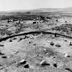
Excavation photograph. Stone circle XI in the foreground with circle I in the background, from the NE. At circle XI stone 4 (F120) is in the foreground with stone 5 (F121) lying out of position to its left. Posthole F110 (Burl's D) is between stones 4 and 5. |
1985 |
Item Level |
|
 |
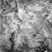
On-line Digital Images |
DP 252787 |
Historic Environment Scotland |
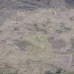
Oblique aerial view. |
3/5/2017 |
Item Level |
|
 |
On-line Digital Images |
DP 252788 |
Historic Environment Scotland |
Oblique aerial view. |
3/5/2017 |
Item Level |
|
 |
On-line Digital Images |
DP 252789 |
Historic Environment Scotland |
Oblique aerial view. |
3/5/2017 |
Item Level |
|
 |
On-line Digital Images |
DP 252791 |
Historic Environment Scotland |
Oblique aerial view. |
3/5/2017 |
Item Level |
|
 |
On-line Digital Images |
DP 252795 |
Historic Environment Scotland |
Oblique aerial view. |
3/5/2017 |
Item Level |
|
 |
On-line Digital Images |
DP 252796 |
Historic Environment Scotland |
Oblique aerial view. |
3/5/2017 |
Item Level |
|
 |
On-line Digital Images |
DP 252797 |
Historic Environment Scotland |
Oblique aerial view. |
3/5/2017 |
Item Level |
|
 |
On-line Digital Images |
DP 252798 |
Historic Environment Scotland |
Oblique aerial view. |
3/5/2017 |
Item Level |
|
 |
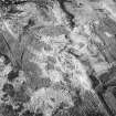
On-line Digital Images |
SC 1671719 |
Records of the Ordnance Survey, Southampton, Hampshire, England |
Plan, copied from Ordnance Survey Record Card |
13/9/1977 |
Item Level |
|
 |
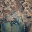
On-line Digital Images |
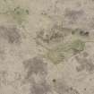
SC 1723819 |
RCAHMS Aerial Photography |
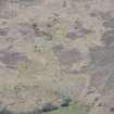
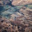
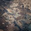
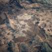
Machrie Moor, oblique aerial view, centred on a group of stone circles. |
13/12/1996 |
Item Level |
|
 |
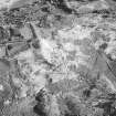
On-line Digital Images |
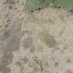
SC 1723821 |
RCAHMS Aerial Photography |
Machrie Moor, oblique aerial view, centred on three stone circles. |
13/12/1996 |
Item Level |
|
 |
On-line Digital Images |
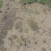
SC 1723823 |
RCAHMS Aerial Photography |
Machrie Moor, oblique aerial view, centred on three stone circles. |
13/12/1996 |
Item Level |
|
 |
On-line Digital Images |
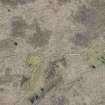
SC 1723825 |
RCAHMS Aerial Photography |
Machrie Moor, oblique aerial view, centred on two stone circles. |
13/12/1996 |
Item Level |
|
 |
On-line Digital Images |
SC 1783129 |
RCAHMS Aerial Photography |
Machrie Moor, oblique aerial view, centred on three stone circles. |
13/12/1996 |
Item Level |
|
 |
On-line Digital Images |
SC 1783131 |
RCAHMS Aerial Photography |
Machrie Moor, oblique aerial view, centred on two stone circles. |
13/12/1996 |
Item Level |
|
 |
On-line Digital Images |
SC 1783132 |
RCAHMS Aerial Photography |
Machrie Moor, oblique aerial view, centred on three stone circles. |
13/12/1996 |
Item Level |
|
 |
On-line Digital Images |
SC 1783143 |
RCAHMS Aerial Photography |
Machrie Moor and Moss Farm, oblique aerial view, with three stone circles in the top half of the photograph and a hut-circle and possible hut-circle in the bottom half. |
13/12/1996 |
Item Level |
|
 |
On-line Digital Images |
SC 1783144 |
RCAHMS Aerial Photography |
Machrie Moor and Moss Farm, oblique aerial view, with the stone circles in the top half of the photograph and a hut-circle and possible hut-circle in the bottom half. |
13/12/1996 |
Item Level |
|
 |
On-line Digital Images |
SC 1905371 |
Records of Historic Scotland, Edinburgh, Scotland |
Excavation photograph. Site XI, pit K showing layer 3, from E. Half sectioned but not cleaned. Look for dark inner circle. |
1979 |
Item Level |
|
 |
On-line Digital Images |
SC 1905374 |
Records of Historic Scotland, Edinburgh, Scotland |
Excavation photograph. Site XI, pit J, from SW. Central post pipe removed only. |
1979 |
Item Level |
|
 |
On-line Digital Images |
SC 1905375 |
Records of Historic Scotland, Edinburgh, Scotland |
Excavation photograph. Site XI, pit J, from NE. Very poor light, strong wind and rain, well cleaned but hard to see in conditions. |
1979 |
Item Level |
|
 |
On-line Digital Images |
SC 1905376 |
Records of Historic Scotland, Edinburgh, Scotland |
Excavation photograph. Site XI, pit A, from W, to show section and pit half excavated. Poor light, not fully cleaned. |
1979 |
Item Level |
|
 |
On-line Digital Images |
SC 1905377 |
Records of Historic Scotland, Edinburgh, Scotland |
Excavation photograph. Site XI, pit J, from S. Awkward shaped pit. Poor light, oblique view taken to show left hand side profile. |
1979 |
Item Level |
|


