
Lud Castle


Fort (Period Unknown)
Site Name Lud Castle
Classification Fort (Period Unknown)
Alternative Name(s) Tanglehall
Canmore ID 35532
Site Number NO64SE 5
NGR NO 6805 4342
Datum OSGB36 - NGR
Permalink http://canmore.org.uk/site/35532


- Council Angus
- Parish Arbroath And St Vigeans
- Former Region Tayside
- Former District Angus
- Former County Angus
NO64SE 5.00 6805 4342.
NO64SE 5.01 6805 4338 Midden; Disc: Stone-Perforated
(NO 6805 4342) Lud Castle (NAT) Fort (NR)
OS 6" map (1970)
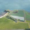
Lud Castle: A promontory fort formed by isolating a promontory, with 100' high precipitous sides, by means of a single rampart at the top of a grassy slope 15m high on the seaward side of a narrow neck of land. The rampart is 1.2m high, spread to 4 - 6m. Christison (1899) notes signs of a passage cut through the S end of the rampart and the entrance seems more likely to have been on the N, where there is a 12.0m gap. Neither is very convincing.
Visited by OS (JLD) 10 June 1958
As described.
Revised at 25" scale.
Visited by OS (WDJ) 21 October 1965
Apart from the single rampart on the promontory, there is a puzzling earthwork on the cliff overlooking the connecting neck. A spindle whorl from the fort is in Dundee Museum, donated by Mrs J Wilson, 31 Keptie Road, Arbroath.
Dundee Museum Record Card, 1975.
Field Visit (2 August 1956)
This site was included within the RCAHMS Marginal Land Survey (1950-1962), an unpublished rescue project. Site descriptions, organised by county, are available to view online - see the searchable PDF in 'Digital Items'. These vary from short notes, to lengthy and full descriptions. Contemporary plane-table surveys and inked drawings, where available, can be viewed online in most cases - see 'Digital Images'. The original typecripts, notebooks and drawings can also be viewed in the RCAHMS search room.
Information from RCAHMS (GFG) 19 July 2013.
Note (4 June 2015 - 31 May 2016)
This small fortification is situated on the raised tip of a heavily eroded promontory girt with high cliffs and approachable only from the W across a narrow neck. The defences comprise a single earthen rampart from 4m to 6m in thickness and up to 1.2m in height, which stands where the tip of the promontory broadens out above the neck. The top of the promontory, however, measures no more than 40m in breadth at this point and while its N margin extends in a narrow finger about 55m out into the sea beyond the rampart, a substantial part of the interior must have collapsed into the sea cave eroded into its S flank. On the S flank below the top of the promontory a small area of eroding midden was found in 1998 and a perforated sandstone disc and animal bones were recovered; a spindle whorl had previously been found at the fort (Dundee Museum). In addition to the rampart defending the tip of the promontory, there is also a curious arrangement of banks on the landward side, described in the Scheduling document (1998) as 'an enclosure measuring about 15m by 8m...[possibly] positioned to control access to the main part of the fort'; aerial photographs show what may be a trackway hollow leading down to the narrow neck, with two banks some 30m in length set parallel to each other along the irregular cliff edge on the N. The date and purpose of these remains is unknown. Equally uncertain is the character of some cropmarks photographed in 1984 in the field some 250m to the WSW and apparently comprising a ditch about 4m in breadth cutting from N to S from the lip of Laverock Den, a steep-sided gully, on the N to the coastal cliffs on the S. If truly a ditch, it would cut off a promontory measuring about 335m from N to S by 260m transversely, taking in a total area of about 8ha. This would be an unusual enclosure, but the presence of a natural feature known as Gaylet Pot within the projected interior raises a note of caution. This feature is the result of subsidence where the sea has eroded deep back under the land along a weakness in the strata. Vertical banding and fissures in the cliffs from which this cropmark springs on the S is perhaps indicative of similar features surfacing in the field, though not eroding in the same way.
Information from An Atlas of Hillforts of Great Britain and Ireland – 31 May 2016. Atlas of Hillforts SC3098

