 |
On-line Digital Images |
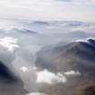
DP 110074 |
RCAHMS Aerial Photography Digital |
General oblique aerial view looking down Loch Treig towards Rannoch and Mamore with Stob Coire Easain to the right, taken from the NNE. |
14/11/2011 |
Item Level |
|
 |
On-line Digital Images |
SC 2386668 |
Records of the Ordnance Survey, Southampton, Hampshire, England |
Eilean Tigh Na Slige, NN37NW 1, Ordnance Survey index card, Recto |
1958 |
Item Level |
|
 |
On-line Digital Images |
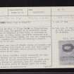
SC 2386669 |
Records of the Ordnance Survey, Southampton, Hampshire, England |
Eilean Tigh Na Slige, NN37NW 1, Ordnance Survey index card, page number 1, Recto |
1958 |
Item Level |
|
 |
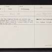
On-line Digital Images |
SC 2386670 |
Records of the Ordnance Survey, Southampton, Hampshire, England |
Eilean Tigh Na Slige, NN37NW 1, Ordnance Survey index card, page number 2, Verso |
1958 |
Item Level |
|
 |
On-line Digital Images |
SC 2674447 |
Records of the Ordnance Survey, Southampton, Hampshire, England |
Loch Treig, NN37SW 1, Ordnance Survey index card, Recto |
1958 |
Item Level |
|
 |
On-line Digital Images |
SC 2674465 |
Records of the Ordnance Survey, Southampton, Hampshire, England |
Loch Treig, NN37SW 1, Ordnance Survey index card, Recto |
1958 |
Item Level |
|


