
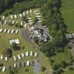
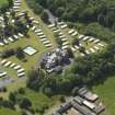
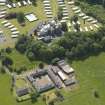
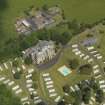
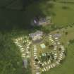
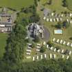
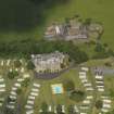
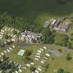
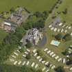
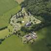
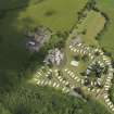
Dankeith House


Country House (18th Century)
Site Name Dankeith House
Classification Country House (18th Century)
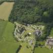
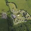
Alternative Name(s) Dankeith Leisure Centre
Canmore ID 202722
Site Number NS33SE 45
NGR NS 38320 33189
Datum OSGB36 - NGR
Permalink http://canmore.org.uk/site/202722


- Council South Ayrshire
- Parish Symington (Kyle And Carrick)
- Former Region Strathclyde
- Former District Kyle And Carrick
- Former County Ayrshire
NS33SE 45.00 NS 38320 333189
NS33SE 45.01 NS 38274 32965 Dankeith House, Hothouses
EXTERNAL REFERENCE:
Architects: 14 Cathcart St. 1894, 1906. Water Supply.
42 Newmarket St. 1882. Adds & alts for J.L.White.
" " 1882. Adds & alts to stables & kitchen Offices.
" " 1882. New Gate Lodge.
14 Cathcart St. 1893-94 & 1909. Adds & alts.
Plans: at Darley Hay Partnership, Ayr.
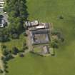
Large, asymmetrical, turreted and castellated Tudor, 2-and 3-storey mansion house with 8-bays to principal, entrance elevation to SE and with polygonal corner turrets. Sandstone ashlar, rubble to rear. Deep base course, band course, corbelled blocking course. Hoodmoulds. Raised cills and moulded architraves. Tudor-arched ground floor window openings. Some canted bay windows; some bi-and tri-partite windows with stone mullions and transoms. Some small, flat-roofed dormers. SW elevation with decorative cast iron imperial stair to garden by James Allan and Son. Raised ashlar quoins to corners at rear. Predominantly plate glass timber sash and case windows. Grey slates, cast iron rainwater goods. Ridge and gable stacks with polygonal stone stacks.
Predominantly dating from the 19th century, this is a fine example of a large country mansion in the castellated Tudor style. The house sits on a small hill and its stepped roofline, castellated towers and tall chimneystacks contribute to its significant presence in the landscape. The house is composed of a number of different building periods, but retains a cohesive design. The interior has a fine timber stair and screen in the entrance hall. The house is likely to date originally from the later part of the 18th century and is depicted on the 1775 Andrew Armstrong New Map of Ayrshire. A rubble section with raised quoins at the rear of the house may be part of this earlier period.
By the time of the 1st Edition Ordnance Survey Map in 1860 the house has been extended to the north east. The house was bought in 1881 by James Lumsden White who carried out significant improvements. These were designed by the Ayr architect Allan Stevenson. He designed additions and extensions and a new gate lodge (now demolished). In 1893-4 and in 1909, he made further additions and extensions under a new owner, Mann Thomson.
In 1930, further alterations and additions were made after fire damage to the designs of James Miller. The house was used as a military headquarters during WWII and then became a monastery between 1948 and 1968. Internal alterations to make numerous small bedrooms probably date from this period.
The cast iron stair on the garden elevation is by James Allan Snr and Son's Elmbank Foundry was based in Glasgow and was in existence from 1845-1960. They manufactured a variety of iron goods, including lamp stands, balconies and stairs and their work was widely exported. (Historic Scotland)

