
Kirbister Mill


Grain Mill (18th Century), Watermill (18th Century)
Site Name Kirbister Mill
Classification Grain Mill (18th Century), Watermill (18th Century)
Alternative Name(s) Kirbister Meal Mill
Canmore ID 1946
Site Number HY30NE 27
NGR HY 36878 07097
Datum OSGB36 - NGR
Permalink http://canmore.org.uk/site/1946


- Council Orkney Islands
- Parish Orphir
- Former Region Orkney Islands Area
- Former District Orkney
- Former County Orkney
HY30NE 27 36878 07097
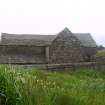
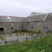
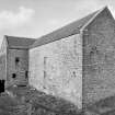
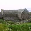
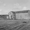
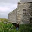
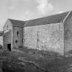
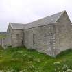
(Location cited as HY 368 072). Kirbister Mill, 18th century. A large 3-storey and attic flagstone rubble range on a T plan, with a lean-to wheelhouse, now gutted and used as a store.
J R Hume 1977.
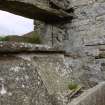
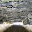
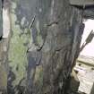
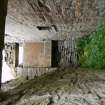
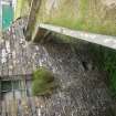
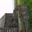
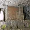
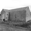
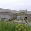
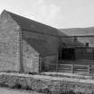
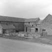
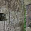
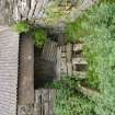
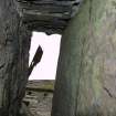
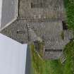
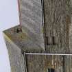
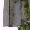
This is a random rubble (flag) built mill complex incorporating two, three-storey kilns and grain mill and a two-storey threshing mill and byre with hay loft. The byre with hay loft range has a flag stone roof, the rest of the mill being roofed in slate. The enclosed waterwheel operating the now gone (probable) three millstones was on the W side of the building. It was an overshot type with a maximum diameter of 4.6m and a maximum width of 1.25m. The now filled-in pit of a second enclosed wheel is situated between the grain milling area on the W and the threshing mill area on the E of the complex. This waterwheel, of the undershot type, probably drove the threshing machinery and measured 3.6m in diameter and 1.4m in width.
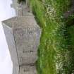
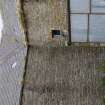
The kilns were housed in the S range, the southernmost being an addition (indicated by differences in the masonry).The framework for the (now gone) kiln plates is still in place indicating that they were 0.3m square. There is a date stone in the floor of the grain milling area (first floor) bearing initials and the date '1889'.
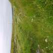
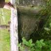
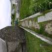
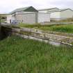
The lade is constructed from stone and measures 1.06m in width and 0.33m in depth. The sides of the trough are 5cm in width and 1 cm in thickness and are bolted to the base of the trough. There are the remains of a hinge where the two arms of the lade bifurcate, allowing the flow of water to be directed to either of the two waterwheels. A sluice was noted some 20m N of the hinge.
The present day layout of the complex is depicted on the 1st edition of the OS 25-inch map (Orkney, 1880, sheet CVII.12) with the exception of the non-enclosure of the waterwheel that probably drove the threshing mill. By 1902, this waterwheel had been enclosed (OS 25-inch map, Orkney, 1902, sheet CVII.12).
Visited by the Scottish Industrial Archaeology Survey (GJD), 24 October 1981.
See NMRS MS/500/35/29 for details
2 1/2 storey meal mill in random rubble with a Caithness slate roof. A pent-house (formerly over the wheel) sits to the west, whilst a barn sits to the east. The mill originally contained 2 kilns and 2 waterwheels, for milling and threshing respectively.
Publication Account (1977)
(Location cited as HY 368 072). Kirbister Mill, 18th century. A large 3-storey and attic flagstone rubble range on a T plan, with a lean-to wheelhouse, now gutted and used as a store.
J R Hume 1977.
Field Visit (October 1981)
This is a random rubble (flag) built mill complex incorporating two, three-storey kilns and grain mill and a two-storey threshing mill and byre with hay loft. The byre with hay loft range has a flag stone roof, the rest of the mill being roofed in slate. The enclosed waterwheel operating the now gone (probable) three millstones was on the W side of the building. It was an overshot type with a maximum diameter of 4.6m and a maximum width of 1.25m. The now filled-in pit of a second enclosed wheel is situated between the grain milling area on the W and the threshing mill area on the E of the complex. This waterwheel, of the undershot type, probably drove the threshing machinery and measured 3.6m in diameter and 1.4m in width.
The kilns were housed in the S range, the southernmost being an addition (indicated by differences in the masonry).The framework for the (now gone) kiln plates is still in place indicating that they were 0.3m square. There is a date stone in the floor of the grain milling area (first floor) bearing initials and the date '1889'.
The lade is constructed from stone and measures 1.06m in width and 0.33m in depth. The sides of the trough are 5cm in width and 1 cm in thickness and are bolted to the base of the trough. There are the remains of a hinge where the two arms of the lade bifurcate, allowing the flow of water to be directed to either of the two waterwheels. A sluice was noted some 20m N of the hinge.
The present day layout of the complex is depicted on the 1st edition of the OS 25-inch map (Orkney, 1880, sheet CVII.12) with the exception of the non-enclosure of the waterwheel that probably drove the threshing mill. By 1902, this waterwheel had been enclosed (OS 25-inch map, Orkney, 1902, sheet CVII.12).
Visited by the Scottish Industrial Archaeology Survey (GJD), 24 October 1981.
See NMRS MS/500/35/29 for details
Photographic Record (29 July 2010)

