
Turriff, Deveron Bridge, Tollhouse


Toll House (Post Medieval)
Site Name Turriff, Deveron Bridge, Tollhouse
Classification Toll House (Post Medieval)
Alternative Name(s) Turriff, Knockiemill Lodge, Old Tollhouse; Turriff Angling Association Shelter; Forglen, Eastside Bridge, Tollhouse
Canmore ID 19267
Site Number NJ75SW 21
NGR NJ 71435 50387
Datum OSGB36 - NGR
Permalink http://canmore.org.uk/site/19267


- Council Aberdeenshire
- Parish Turriff
- Former Region Grampian
- Former District Banff And Buchan
- Former County Aberdeenshire
NJ75SW 21 71435 50387
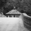
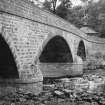
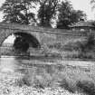
For adjacent (to SW) Deveron Bridge, see NJ75SW 20.
NMRS NOTES
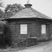
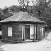
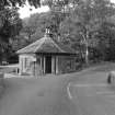
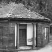
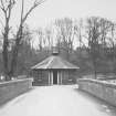
Turriff, Deveron, Old Toll House.
ARCHITECT: William Robertson 1826.
(Undated) information in NMRS.
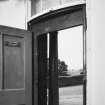
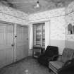
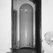
(Location cited as NJ 714 503). Bridge and tollhouse, Turriff, built 1826. The tollhouse is a neat hexagonal structure, with columns flanking the door, now used as an anglers' shelter.
J R Hume 1977.
This building is depicted, but not noted, on the 1989 edition of the OS 1:10,000 map and the current OS (GIS) AIB.
Information from RCAHMS (RJCM), 6 June 2006.

