|
Photographs and Off-line Digital Images |
E 25995 CN |
Records of the Northern Lighthouse Board, Edinburgh, Scotland |
Photographic copy of drawing showing sections across the cutting, embankment, side cutting and cross drain. |
c. 1855 |
Item Level |
|
|
Photographs and Off-line Digital Images |
E 25996 |
Records of the Northern Lighthouse Board, Edinburgh, Scotland |
Photographic copy of drawing showing plan, section and elevation of tower. In addition, plan of floor beams and elevations of hatchway, centre beams.
Northern Lights, sheet No.2 |
3/3/1855 |
Item Level |
|
|
Photographs and Off-line Digital Images |
E 25997 CN |
Records of the Northern Lighthouse Board, Edinburgh, Scotland |
Photographic copy of drawing showing plan, section and elevation of tower. In addition, plan of floor beams and elevations of hatchway, centre beams.
Northern Lights, sheet No.2 |
3/3/1855 |
Item Level |
|
|
Photographs and Off-line Digital Images |
E 25998 |
Records of the Northern Lighthouse Board, Edinburgh, Scotland |
Photographic copy of sketch drawing showing section of the ground and elevation and plan of store house. |
6/1857 |
Item Level |
|
|
Photographs and Off-line Digital Images |
E 25999 CN |
Records of the Northern Lighthouse Board, Edinburgh, Scotland |
Photographic copy of sketch drawing showing section of the ground and elevation and plan of store house. |
6/1857 |
Item Level |
|
|
Prints and Drawings |
DC 9212 |
Records of the Northern Lighthouse Board, Edinburgh, Scotland |
Drawing showing sections of road for Ushenish Lighthouse, South Uist. |
3/3/1855 |
Item Level |
|
|
Photographs and Off-line Digital Images |
E 25977 |
Records of the Northern Lighthouse Board, Edinburgh, Scotland |
Photographic copy of drawing showing sections of road.
Northern Lights, sheet No.5 |
3/3/1855 |
Item Level |
|
|
Photographs and Off-line Digital Images |
E 25979 |
Records of the Northern Lighthouse Board, Edinburgh, Scotland |
Photographic copy of drawing showing section at site of lighthouse and small map showing location. |
17/7/1855 |
Item Level |
|
|
Photographs and Off-line Digital Images |
SC 781406 |
Records of the Northern Lighthouse Board, Edinburgh, Scotland |
Scanned image of drawing showing section, plan and elevation of tower.
|
3/3/1855 |
Item Level |
|
|
Photographs and Off-line Digital Images |
SC 781413 |
Records of the Northern Lighthouse Board, Edinburgh, Scotland |
Scanned image of photographic copy of elevation, plan and section of dwelling houses and elevation and plan of gate and enclosure wall.
|
3/3/1855 |
Item Level |
|
|
Photographs and Off-line Digital Images |
SC 781418 |
Records of the Northern Lighthouse Board, Edinburgh, Scotland |
Scanned image of photographic copy of section of road, retaining wall, and slip.
|
8/1856 |
Item Level |
|
|
Photographs and Off-line Digital Images |
SC 781421 |
Records of the Northern Lighthouse Board, Edinburgh, Scotland |
Scanned image of photographic copy of section, elevation and plan of storehouse and section of boundary wall.
|
12/1856 |
Item Level |
|
|
Photographs and Off-line Digital Images |
E 26065 CN |
Records of the Northern Lighthouse Board, Edinburgh, Scotland |
Photographic copy of drawing showing plan of water tank and filter. |
10/1856 |
Item Level |
|
|
Photographs and Off-line Digital Images |
E 26064 |
Records of the Northern Lighthouse Board, Edinburgh, Scotland |
Photographic copy of drawing showing plan of water tank and filter. |
10/1856 |
Item Level |
|
|
Manuscripts |
MS 2954 |
Historic Scotland Archive Project |
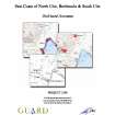
Archive from a coastal zone assessment survey of East Coast of North Uist, Benbecula and South Uist. |
31/3/2006 |
Item Level |
|
 |
Digital Files (Non-image) |
WP 000274 |
Records from the Department of Archaeology, University of Glasgow, Glasgow, Scotland |
Archive from a coastal zone assessment survey of East Coast of North Uist, Benbecula and South Uist. |
31/3/2006 |
Item Level |
|
 |
On-line Digital Images |
DP 110526 |
RCAHMS Aerial Photography Digital |
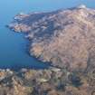
General oblique aerial view of the remains of the townships of Molatuath and Glacklee and nearby field boundaries and lazy beds, looking towards Ushenish lighthouse, S Uist, taken from the W. |
14/11/2011 |
Item Level |
|
 |
On-line Digital Images |
DP 110528 |
RCAHMS Aerial Photography Digital |
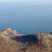
General oblique aerial view through Gleann Mile-feala towards Ushenish lighthouse, S Uist, taken from the W. |
14/11/2011 |
Item Level |
|
 |
On-line Digital Images |
DP 171639 |
Records of the Royal Commission on the Ancient and Historical Monuments of Scotland (RCAHMS), Edinbu |
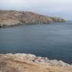
General view looking towards Usinish lighthouse. |
23/4/2013 |
Item Level |
|
 |
On-line Digital Images |
DP 171640 |
Records of the Royal Commission on the Ancient and Historical Monuments of Scotland (RCAHMS), Edinbu |
General view looking towards Usinish lighthouse |
23/4/2013 |
Item Level |
|
|
Photographs and Off-line Digital Images |
SC 1383420 |
Records of the Northern Lighthouse Board, Edinburgh, Scotland |
Photographic copy of drawing showing plan and section of roofs of dwelling houses.
Northern Lights, sheet No.4 |
3/3/1855 |
Item Level |
|
|
Photographs and Off-line Digital Images |
SC 1383421 |
Records of the Northern Lighthouse Board, Edinburgh, Scotland |
Photographic copy of drawing showing section through centre line and section of the cutting of footpath from dwelling house to tower. |
10/5/1856 |
Item Level |
|
|
Photographs and Off-line Digital Images |
SC 1383422 |
Records of the Northern Lighthouse Board, Edinburgh, Scotland |
Photographic copy of drawing showing plan of the landing place, the proposed route of the road and the site of the lighthouse and dwelling houses.
Northern Lights, sheet No.1 |
3/3/1855 |
Item Level |
|
|
Photographs and Off-line Digital Images |
SC 1383423 |
Records of the Northern Lighthouse Board, Edinburgh, Scotland |
Photographic copy of drawing showing sections across the cutting, embankment, side cutting and cross drain. |
1855 |
Item Level |
|


