
Easterton Of Roseisle


Burial Ground(S) (Period Unassigned), Unidentified Flint(S) (Flint)
Site Name Easterton Of Roseisle
Classification Burial Ground(S) (Period Unassigned), Unidentified Flint(S) (Flint)
Canmore ID 16253
Site Number NJ16SW 24
NGR NJ 145 649
NGR Description NJ c. 145 649
Datum OSGB36 - NGR
Permalink http://canmore.org.uk/site/16253


- Council Moray
- Parish Duffus
- Former Region Grampian
- Former District Moray
- Former County Morayshire
NJ16SW 24 c. 145 649.
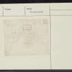
(Area NJ 145 649) In May 1894, what appears to have been an enclosed cemetery of several hundred extended inhumations was discovered during ploughing in a sandy field on Easterton of Roseisle farm.
It measured about 50 yards E-W by 30 yards N-S within an earthen bank, with an internal wall of clay, 12" to 18" wide and 8" deep, the clay having been brought from about 30 yards away. The purpose of this division was not clear.
The skeletons, all apparently of adults, young and old, lay N-S, in rows, on their backs and almost touching each other. There were both dolichocephalic and brachy- cephalic skulls and one was thought to be that of a woman. Walker implies that a box of bones in Burghead Museum apertains to this site, but the bones have not been studied by an anatomist.
Scrapers and worked flints were found among the burials, but these are probably intrusive, deriving from the spread of stone implements all over the field (NJ16SW 28).
Young's sitings of the burial-ground are so conflicting as to locate it to either NJ 139 649 (1,000 yards WSW of Easterton) or NJ 145 647 (483 yards east of NJ16SW 25). The first falls c.220 yards NNW of NJ16SW 25; the second falls in an area which, air photographs (Visible on RAF air photographs F22.58.RAF. 1146: 0070-1: flown 24 June 1953) suggest, is so low lying as to have formed part of the former Loch of Spynie in the none too distant past, perhaps even as recently as 1749. (I C Walker 1968)
Taylor (W A Taylor, Easterton of Roseisle) is convinced that the burial-ground (or 'battle') was situated at NJ145 649 although he admits that he knows of no finds since his family acquired the property in 1902. The site does however agree topographically with Young's sketch plan and is much nearer Spindle Muir (NJ 15 65), where Allen (J R Allen and J Anderson 1903) says the burials were found, just below the 50' contour, than either of Young's sitings. It is also approximately 483 yards from NJ16SW 25, although to the NE rather than the east.
The exposure of the burials is said to have been due ultimately to sand-blow lowering the level of the field. This was so severe in 1898 that, with a westerly gale, the sand blocked the roads.
(Taylor's site has been accepted as the most likely, though by no stretch of the imagination could it be described as 1,000 yards WSW of Easterton farm-house).
Visited by OS (A A) 7 February 1972.
H W Young 1895; H W Young 1896; J R Allen and J Anderson 1903; I C Walker 1968.

