
Hillhead, Radar Station, Type 24 Pillbox


Pillbox (20th Century)
Site Name Hillhead, Radar Station, Type 24 Pillbox
Classification Pillbox (20th Century)
Alternative Name(s) Hillhead Radar Station Defences; Smiddyseat
Canmore ID 250545
Site Number NJ96SW 30.10
NGR NJ 94183 61686
Datum OSGB36 - NGR
Permalink http://canmore.org.uk/site/250545


- Council Aberdeenshire
- Parish Tyrie
- Former Region Grampian
- Former District Banff And Buchan
- Former County Aberdeenshire
NJ96SW 30.10 84183 61686
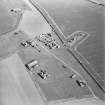
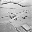
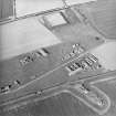
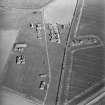
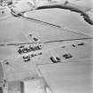
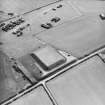
A possible pillbox forming part of the radar station defences, is shown on the OS 1:2500 scale digital map.
Information RCAHMS (DE), September 2003
A type 24 pillbox is situated on a gentle slope to the S of the domestic site and about 120m NW of the type 27 pillbox (NJ96SW 30.04) in the same arable field. As with the type 24 pillbox to the E (NJ96SW 30.09), this structure was formerly located on the metal fence line, recently removed.
The pillbox is six sided of concrete construction and measures about 6m across. The entrance on the NW is prtotected by a short blast wall and between it and the pillbox is a small heap of stone and concrete rubble. There would appear to be loopholes in all the sides except that of the entrance.
Visited by RCAHMS (DE, NG), 28 February 2008

