
Hillhead, Radar Station, Type 27 Pillbox


Pillbox (20th Century)
Site Name Hillhead, Radar Station, Type 27 Pillbox
Classification Pillbox (20th Century)
Alternative Name(s) Hillhead Radar Station Defences; Smiddyseat
Canmore ID 224654
Site Number NJ96SW 30.04
NGR NJ 94259 61591
Datum OSGB36 - NGR
Permalink http://canmore.org.uk/site/224654


- Council Aberdeenshire
- Parish Tyrie
- Former Region Grampian
- Former District Banff And Buchan
- Former County Aberdeenshire
NJ96SW 30.04 94259 61591
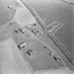
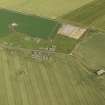
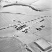
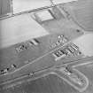
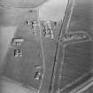
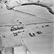
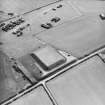
This type 27 pillbox is visible on post-war RAF vertical air photographs (V/RAF/882, 67-8, flown 30 March 1954) 100m to the S of the main elements of the radar station.
Information from RCAHMS (DE), October 2002
A large type 27 brick and concrete pillbox is situated in an arable field about 70m S of the S perimeter fence line. It measures about 7.5m across with a flat concrete roof whilst the base is of brick.The building has eight sides each with a loophole with the entrance in the NE segment.
This pillbox is very similar to that found to the N (NJ96SW 30.07).
Visited by RCAHMS (DE, NG), 28 February 2008

