
Hillhead, Radar Station, Receiver Block


Building (20th Century)
Site Name Hillhead, Radar Station, Receiver Block
Classification Building (20th Century)
Alternative Name(s) Smiddyseat
Canmore ID 224652
Site Number NJ96SW 30.03
NGR NJ 94109 61875
Datum OSGB36 - NGR
Permalink http://canmore.org.uk/site/224652


- Council Aberdeenshire
- Parish Tyrie
- Former Region Grampian
- Former District Banff And Buchan
- Former County Aberdeenshire
NJ96SW 30.03 94109 61875
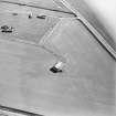
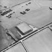
The Receiver Block is visible on post-war RAF vertical air photographs (V/RAF/882, 67-8, flown 30 March 1954) surrounded by four masts. It is depicted on the OS 1:10000 scale map (1980).
Information from RCAHMS (DE), October 2002
The Radar Receiver block is situated in an arable on the NW side of the site about 145m NW of the domestic accommodation site (NJ96SW 30.14). The building was not examined during the visit as it is located in a field of growing crops.
The building is similar to the transmitter block (NJ96SW 30.01) in appearance, but would appear to be smaller in size. Measurements taken from the OS 1:2500 scale digital map show it to be approximately 21.7m by 14.8m with the inner block measuring approximately 18.1m by 8.7m. The main entrance at the SW end has also been enlarged to allow tractors to enter with bales of straw/hay. The flat roofed inner block is constructed of brick which can be seen through the entrance.
Visited by RCAHMS (DE, NG), 28 February 2008

