|
Manuscripts |
MS 712/6 |
General Collection |
Copy of Grampian Regional Council SMR record sheet for updates to the SMR in 1994. |
1994 |
Item Level |
|
|
Manuscripts |
MS 810/1 |
Records of Historic Scotland, Edinburgh, Scotland |
Grampian. World War One and Two Defences of Grampian. A survey by John Guy
Volumes 1 & 2 |
1993 |
Item Level |
|
|
Photographs and Off-line Digital Images |
C 47680 |
Records of the German Air Force (Luftwaffe), Second World War Aerial Reconnaissance |
Aerial view. |
1940 |
Item Level |
|
|
Photographs and Off-line Digital Images |
C 47680 S |
Records of the German Air Force (Luftwaffe), Second World War Aerial Reconnaissance |
Aerial view. |
1940 |
Item Level |
|
|
Manuscripts |
MS 712/9 |
Records of Aberdeenshire Archaeology Service, Aberdeen, Scotland
|
Photocopies of record sheet relating to updates to the Grampian Regional Council SMR, 1994-5. |
1994 |
Item Level |
|
|
Photographs and Off-line Digital Images |
E 94679 PO |
Records of Aberdeenshire Archaeology Service, Aberdeen, Scotland
|
Oblique aerial photograph of Hillhead radar station, pillboxes and camp, taken from the WSW centred on the remains of the radar station and camp. |
15/2/2000 |
Item Level |
|
|
Photographs and Off-line Digital Images |
E 94680 PO |
Records of Aberdeenshire Archaeology Service, Aberdeen, Scotland
|
Oblique aerial photograph of Hillhead radar station, pillboxes and camp, taken from the SW centred on the remains of the radar station and camp. |
15/2/2000 |
Item Level |
|
|
Photographs and Off-line Digital Images |
E 94681 PO |
Records of Aberdeenshire Archaeology Service, Aberdeen, Scotland
|
Oblique aerial photograph of Hillhead radar station, pillboxes and camp, taken from the SSE centred on the remains of a pillbox. |
15/2/2000 |
Item Level |
|
|
Photographs and Off-line Digital Images |
E 94682 PO |
Records of Aberdeenshire Archaeology Service, Aberdeen, Scotland
|
Oblique aerial photograph of Hillhead radar station, pillboxes and camp, taken from the NNW centred on the remains of a pillbox. |
15/2/2000 |
Item Level |
|
|
Photographs and Off-line Digital Images |
E 94683 PO |
Records of Aberdeenshire Archaeology Service, Aberdeen, Scotland
|
Oblique aerial photograph of Hillhead radar station, pillboxes and camp, taken from the N centred on the remains of the radar station and camp. |
15/2/2000 |
Item Level |
|
|
Photographs and Off-line Digital Images |
E 94684 PO |
Records of Aberdeenshire Archaeology Service, Aberdeen, Scotland
|
Oblique aerial photograph of Hillhead radar station, pillboxes and camp, taken from the NW centred on the remains of the radar station and camp. |
15/2/2000 |
Item Level |
|
|
Photographs and Off-line Digital Images |
SC 797396 |
Records of the German Air Force (Luftwaffe), Second World War Aerial Reconnaissance |
Scanned iamge of Luftwaffe vertical air photograph of Chain Home Radar Station, Hillhead (Smiddyseat) and surrounding area, Aberdeenshire. |
1940 |
Item Level |
|
|
Manuscripts |
MS 879/47 |
|
Photocopy of War Diary dated 12 October 1942 of 51st AA Brigade detailing movements of HAA Batteries/ Personnel in Scotland |
|
Item Level |
|
|
Manuscripts |
MS 879/33 |
|
Letter from Ian Brown dated 11 November 1998 enclosing copies of typed lists and maps showing locations of wartime and post-war radar and radio navigation aids sites in Scotland. |
11/11/1998 |
Item Level |
|
|
Manuscripts |
MS 2043/14 |
Records of the Council for British Archaeology, York, England |
Defence of Britain Project recording form. Council of British Archaeology.
Aberdeenshire. Former Grampian Region.
Details of RAF Radar Station, Hillhead, (NJ96SW30). Letter by Supervisor with copy maps of location.
maps and narative |
17/7/1997 |
Item Level |
|
|
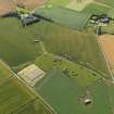
Photographs and Off-line Digital Images |
E 06572 |
RCAHMS Aerial Photography |
Oblique aerial view centred on the remains of the radar station, and pillboxes, taken from the NNE. |
3/5/2001 |
Item Level |
|
|
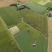
Photographs and Off-line Digital Images |
E 06576 |
RCAHMS Aerial Photography |
Oblique aerial view centred on the remains of the radar station, and pillboxes, taken from the W. |
3/5/2001 |
Item Level |
|
|
Photographs and Off-line Digital Images |
E 06571 |
RCAHMS Aerial Photography |
Oblique aerial view centred on the remains of the radar station, and pillboxes, taken from the NE. |
3/5/2001 |
Item Level |
|
|
Photographs and Off-line Digital Images |
E 06577 |
RCAHMS Aerial Photography |
Oblique aerial view centred on the remains of the radar station, and pillboxes, taken from the SW. |
3/5/2001 |
Item Level |
|
|
Photographs and Off-line Digital Images |
E 06578 |
RCAHMS Aerial Photography |
Oblique aerial view centred on the remains of the radar station, pillboxes, building and reservoir, taken from the NE. |
3/5/2001 |
Item Level |
|
|
Photographs and Off-line Digital Images |
E 06575 |
RCAHMS Aerial Photography |
Oblique aerial view centred on the remains of the radar station, pillboxes and building, taken from the NW. |
3/5/2001 |
Item Level |
|
|
Photographs and Off-line Digital Images |
E 06573 |
RCAHMS Aerial Photography |
Oblique aerial view centred on the remains of the radar station and building, taken from the NNW. |
3/5/2001 |
Item Level |
|
 |
On-line Digital Images |
DP 065299 |
RCAHMS Aerial Photography Digital |
General oblique aerial view centred on the remains of the radar station, taken from the NW. |
25/7/2009 |
Item Level |
|
 |
On-line Digital Images |
DP 065300 |
RCAHMS Aerial Photography Digital |
General oblique aerial view centred on the remains of the radar station, taken from the WNW. |
25/7/2009 |
Item Level |
|