
Hillocks Of Garth


Barrow Cemetery (Later Prehistoric), Building(S) (20th Century), Mound(S) (Later Prehistoric), Nissen Hut (20th Century)
Site Name Hillocks Of Garth
Classification Barrow Cemetery (Later Prehistoric), Building(S) (20th Century), Mound(S) (Later Prehistoric), Nissen Hut (20th Century)
Canmore ID 2343
Site Number HY40NE 5
NGR HY 4678 0780
Datum OSGB36 - NGR
Permalink http://canmore.org.uk/site/2343


- Council Orkney Islands
- Parish Kirkwall And St Ola
- Former Region Orkney Islands Area
- Former District Orkney
- Former County Orkney
Field Visit (21 July 1928)
Mounds, Hillocks of Garth, near Garth.
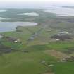
In the corner of a cultivated field about 200 yds NW of the crofter's house at Garth, near Kirkwall, there is a fine group of mounds on high ground between 100 and 200 ft above sea-level. Originally the group has comprised at least nine mounds, but now only five survive in anything like good condition. The sites and approximate diameters of the other four can, however, still be traced, and it is possible that others again have been entirely blotted out in the adjoining cultivated ground. The mounds are all circular on plan; two, which have diameters of 21 feet and 34 ft. respectively, are reduced to mere foundations, and of the others the measurements are respectively 16 ft. by less than 1 ft; 23 ft. by just over 1 ft; 25 ft. by 2 ft; 19 ft. by 1 ft. 6 ins.; 30 ft. by 4 ft. 3 in.; 35 ft. by 4 ft. 6 ins., and 52 ft. by 5 ft. 3 in. All are now covered with turf and heather, but the largest, which was recently cut into by the farmer, proved to consist of an upper layer of blackened peaty soil overlying a mixture of earth mixed with small stones. Some of the mounds seem to have been partially excavated at one time or another, but no record of any finds has been traced.
RCAHMS 1946, visited 21 Jul 1928
OS 6" map cviii
Field Visit (8 April 1964)
HY40NE 5 4678 0780
(HY 4678 0780) Hillocks of Garth (NAT)
OS 6" map, Orkney, 2nd ed. (1903).
The five mounds described above can still be recognised (Nos. 1-5 on survey) but only the site of one other can be identified with certainty (No. 6). Two other features in the vicinity (Nos. 7 & 8) are probably the result of comparatively recent digging. All have been mutilated by surface quarrying and building by the War Department. A segment of stone kerbing is visible at the west perimeter of mound '2'. In the centre of the mound '3' are two parallel slabs of stone 0.8m. long and 0.5m. apart orientated NW - SE which are probably the remains of a cist. (See G.P. AO/64/155/2). This and the appearance of the mounds suggests that they are probably tumuli but the farmer at Garth has found nothing of significance.
Resurveyed at 1/2500
Visited by OS (NKB), 8 April 1964.
Field Visit (11 September 1993)
Visited as part of the Orkney Barrows Project, two bowl-shaped mounds were recorded at Hillocks of Garth.
The first measured 15.4m by 14.1m and 1.85m in height. A structure has been built into the W side. The second measured 6.0m in diameter and 0.4m in height. It was clipped by a track.
Both mounds are visible to the NE for up to 2km.
Information from the Orkney Barrows Project (JD), 1993
Watching Brief (17 October 2007)
HY 4678 0780 An area 20 x 25m close to a group of archaeological mounds was stripped of topsoil and examined for archaeological remains in advance of development on 17 October 2007. No archaeological finds or features were observed.
Archive to be deposited with RCAHMS. Report deposited with Orkney SMR and RCAHMS.
Funder: Mr and Mrs N McLennan.
D Lawrence 2007
Field Visit (9 May 2013)
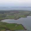
Only three grass-grown mounds – of up to nine recorded by RCAHMS in 1946 and five by the OS in 1964 can now be identified. The NW mound (HY 46780 07811), which is situated immediately NE of a rectangular stone building, measures 11m in diameter and 1.2m in height. The S side of its summit is disfigured by a brick, stone and concrete-lined L-shaped depression up to 0.4m deep, which is all that remains of the small rectangular building noted by the OS. A shallow linear cutting (perhaps for a pipe) can be traced running from this in a NE direction to a point 2m beyond the foot of the mound. The central mound (HY 46783 07793), which is situated 4m to the SSE, measures 15m in diameter and 2.2m high. Its core has been scooped out from the SW to leave a parapet on the NE which rises 0.3m above the general level of its summit. By contrast, the SE mound (HY 46799 07764), which is situated 24.5m to the S, is little more than a swelling measuring 6m from N to S by 5.3m transversely and up to 0.4m high. The whole interior of the roughly trapezoidal enclosure in which the mounds are situated has been heavily trampled and rutted by livestock, while some additional grass-grown, earth-and-stone heaps with strongly rounded profiles have been constructed amongst the older mounds relatively recently.
Although the farmer is known to have cut at least 3ft into the makeup of the central mound in 1935, it is not known whether its present form results entirely from this activity. As both the OS and Hedges indicate, the original mounds were much damaged during WWII when the Nissen hut on the SW side of the enclosure was constructed. This measures about 15m from NW to SE by 4m transversely over hemispherical gables built of concrete blocks, the whole being clad with corrugated iron sheeting curving down to ground level. The NW gable has a door offset to the SW, while the SE gable has a much wider entrance for vehicles. By contrast, the building situated 15m to its north on the NW side of the enclosure measures about 11m from NE to SW by 5m transversely over coursed concrete block walls rising to a gable and with a roof clad in corrugated sheeting. There is a sliding door in its NE gable and a central door flanked by widely spaced single windows in its SE facade. Although this was present in 1964, it is not known whether it was also constructed during WWII or at some later date. The nature of this military occupation is uncertain, but the site has a fine view of the W end of the runway of Kirkwall airport and so it may have been connected with its defence.
Eight mounds are shown on the 1st edition of the OS 6-inch map (Orkney 1882, Sheet CVIII), but only five are denoted on the 2nd edition of the map (Orkney 1903, Sheet CVIII).
Visited by RCAHMS (ATW) 9 May 2013.

