 |
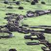
9668 |
St Kilda, Hirta, Village Bay |
Cleit(S) (19th Century) - (20th Century), Consumption Dyke(S) (19th Century), Village (19th Century) - (20th Century) |
NF19NW 21 |
|
|
76138 |
Woods Of Cairnie |
Consumption Dyke(S) (Post Medieval) |
NJ80NW 31 |
|
|
174374 |
Whitehouseburn |
Consumption Dyke (Post Medieval) |
NJ61NW 111 |
|
|
240306 |
Tullos Hill |
Cairn (Period Unassigned), Consumption Dyke (Post Medieval) |
NJ90SE 123 |
|
 |
252295 |
Backhill Of Brodiach |
Consumption Dyke(S) (Post Medieval) |
NJ80NE 193 |
|
|
297535 |
Kingswells, Consumption Dykes, Broad Dyke |
Consumption Dyke (Post Medieval) |
NJ80NE 17.01 |
|
|
297536 |
Kingswells, Consumption Dykes, East Dyke |
Consumption Dyke (Post Medieval) |
NJ80NE 17.02 |
|
|
331255 |
Cranfield |
Consumption Dyke (Post Medieval) |
NJ91SW 201 |
|
|
347807 |
Nigg, Altens Farm Road, Caravan Park |
Consumption Dyke (Post Medieval), Saddle Quern |
NJ90SW 300 |
|
|
350734 |
Altens Farm Road |
Consumption Dyke (Post Medieval), Saddle Quern |
NJ90SW 303 |
|
|
376288 |
Ingleston, Culfad And Woodside |
Clearance Cairn(S) (Period Unknown), Consumption Dyke (Period Unknown), Gravel Pit(S) (19th Century), Mound(S) (Period Unknown), Quarry (19th Century), Shooting Stand (20th Century), Wall(S) (Period Unknown) |
NX77SE 128 |
|
 |
371422 |
Mid Gleniron |
Consumption Dyke (19th Century) |
NX16SE 169 |
|


