
Foulshiels


Boundary Dyke(S) (Post Medieval), Farmstead (Post Medieval), Lazy Beds (Post Medieval), Pen(S) (Post Medieval), Tower (Medieval)(Possible)
Site Name Foulshiels
Classification Boundary Dyke(S) (Post Medieval), Farmstead (Post Medieval), Lazy Beds (Post Medieval), Pen(S) (Post Medieval), Tower (Medieval)(Possible)
Alternative Name(s) Foulshiels Tower
Canmore ID 67922
Site Number NY49SE 4
NGR NY 4922 9161
Datum OSGB36 - NGR
Permalink http://canmore.org.uk/site/67922


- Council Scottish Borders, The
- Parish Castleton
- Former Region Borders
- Former District Roxburgh
- Former County Roxburghshire
NY49SE 4 4922 9161.
(NY 4922 9161) Foulshiels Tower (NR) (Site of)
OS 6" map (1957)
This spot was indicated in 1858 by three local informants as the site of "Foulshiels Tower", said to have been a stronghold of the Elliotts.
Name Book 1858
At the published site, on a level shelf of an E-facing rough pasture slope, are the turf-covered remains of a stony mound approximately 18m in overall diameter and up to 1m high on the E side. A ragged depression about 12m square and 0.5m deep has been dug centrally within the mound, which is further confused by a late turf bank that crosses the low W edge. It is doubtful that this is the site of a building, and although no certain classification can be made, it may be the remains of a burial cairn.
Dr M Robson of Wilton Lodge Museum, has no information on this name, and doubts the existence of a strong house at this locality.
Visited by OS (JRL) 24 August 1979
Field Visit (1 March 1996 - 4 March 1998)
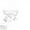
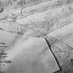
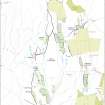
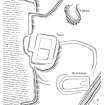
On a terrace about 300m NW of Foulshiels steading there are the site of a tower; two enclosures; a farmstead, comprising a building and an enclosure; a patch of lazy-beds; and a series of boundary dykes.
The tower lies at the foot of a slope at a slight angle to a large rectangular enclosure on the W. It has been completely robbed of its stone, leaving little more than robber-trenches and an external halo of debris. It measures 12m from N to S by 8.5m transversely within the robber-trenches, which are 1.8m broad, and a rectangular feature on the W may mark the location of an external stone stair (LID96 101). To the NE of the tower there is a hollow, which may be a midden scoop. The relationship of the tower to the large enclosure on the W is obscured on the S by the debris halo, and on the N by a secondary bank which cuts through the enclosure bank to abut the NW corner of the robber-trench for the external stair. However, the alignment of the enclosure with the W side of the tower suggests that the enclosure postdates the tower. The bank of the enclosure and the debris halo of the tower overlie the bank of a subrectangular enclosure that forms part of a farmstead, comprising a building and an enclosure. It is uncertain if the farmstead predates the tower as well as the enclosure. The building of the farmstead has a rounded W end and a squared E end, and measures 12.2m in length by 7m in breadth over low grass-grown stony banks, 0.1m in height and spread to 2m in thickness. There is a hollow in the E end suggesting the presence of a byre-drain, and a shallow drainage gully around the W end (LID96 26). The ditch of a later boundary-dyke cuts the SE corner of the building (see below).
At least three main phases can be distinguished amongst the earthen boundary-dykes that enclose the land to the SE of the tower. The primary boundary, comprising a bank with a ditch on the upslope side, which is the easternmost of the three, has a secondary dyke leading off to the SW. In its primary form the boundary runs from the boggy ground to the NE of the tower (NY 4938 9171) as far as the 19th-century drystone field-dyke to the S (NY 4933 9160). The secondary dyke, representing an expansion phase, runs off to the SW, but it is cut by a pen that is attached to the earthen boundary dyke forming the second main phase. Rushes obscured the ground at this point, but it is likely from the various banks that are visible to the SW that both the first and second main phases of boundary continued in some form or other, and include a large enclosure to the S of the tower, the W side of which is aligned with the enclosure to the W of the tower. The third main boundary-dyke, which has a modern drain cut along its NW side and also has a pen built against it, is the westernmost, and cuts obliquely through the enclosure to the S of the tower and the building to its SE. A patch of lazy-beds is located (NY 4931 9162) in a triangular patch of ground between two phases of the primary boundary dyke and the drystone wall of the modern field to the S.
A farm called Foulshielmuir is listed in the 1541 Crown Rental (Stuart and Burnett 1897). Its location is uncertain, but the presence of the tower at this site suggests that it is Nether Foulshiels, mapped by Pont and depicted on Blaeu's atlas (Blaeu 1654) at roughly this location. A single household with one hearth is listed for Nether Foulshiels in the Hearth Tax of 1691, National Archives of Scotland (SRO) E69/21/1) and the farm of Foulshiels appears in the Buccleuch estate survey of 1718, but the depiction on the plan is too generalised to aid identification of the site (Registers of Scotland RHP 9629). Foulshiels is also shown on Roy's map (Roy 1747-55), but again at too small a scale to be certain about the exact location. However, by the date of the 1st edition OS 6-inch map (Roxburghshire 1863, sheet xlii), the farmstead of Foulshiels had been moved from the site of the tower to a position 430m to the S.
(LID96 26 and 101)
Visited by RCAHMS (PJD) 1 March 1996 and 4 March 1998
J Blaeu 1654; W Roy 1747-55; J Stuart and G Burnett 1897
Field Visit (1 March 1996 - 4 March 1998)
On a terrace about 300m NW of Foulshiels steading there are the site of a tower; two enclosures; a farmstead, comprising a building and an enclosure; a patch of lazy-beds; and a series of boundary dykes.
The tower lies at the foot of a slope at a slight angle to a large rectangular enclosure on the W. It has been completely robbed of its stone, leaving little more than robber-trenches and an external halo of debris. It measures 12m from N to S by 8.5m transversely within the robber-trenches, which are 1.8m broad, and a rectangular feature on the W may mark the location of an external stone stair (LID96 101). To the NE of the tower there is a hollow, which may be a midden scoop. The relationship of the tower to the large enclosure on the W is obscured on the S by the debris halo, and on the N by a secondary bank which cuts through the enclosure bank to abut the NW corner of the robber-trench for the external stair. However, the alignment of the enclosure with the W side of the tower suggests that the enclosure postdates the tower. The bank of the enclosure and the debris halo of the tower overlie the bank of a subrectangular enclosure that forms part of a farmstead, comprising a building and an enclosure. It is uncertain if the farmstead predates the tower as well as the enclosure. The building of the farmstead has a rounded W end and a squared E end, and measures 12.2m in length by 7m in breadth over low grass-grown stony banks, 0.1m in height and spread to 2m in thickness. There is a hollow in the E end suggesting the presence of a byre-drain, and a shallow drainage gully around the W end (LID96 26). The ditch of a later boundary-dyke cuts the SE corner of the building (see below).
At least three main phases can be distinguished amongst the earthen boundary-dykes that enclose the land to the SE of the tower. The primary boundary, comprising a bank with a ditch on the upslope side, which is the easternmost of the three, has a secondary dyke leading off to the SW. In its primary form the boundary runs from the boggy ground to the NE of the tower (NY 4938 9171) as far as the 19th-century drystone field-dyke to the S (NY 4933 9160). The secondary dyke, representing an expansion phase, runs off to the SW, but it is cut by a pen that is attached to the earthen boundary dyke forming the second main phase. Rushes obscured the ground at this point, but it is likely from the various banks that are visible to the SW that both the first and second main phases of boundary continued in some form or other, and include a large enclosure to the S of the tower, the W side of which is aligned with the enclosure to the W of the tower. The third main boundary-dyke, which has a modern drain cut along its NW side and also has a pen built against it, is the westernmost, and cuts obliquely through the enclosure to the S of the tower and the building to its SE. A patch of lazy-beds is located (NY 4931 9162) in a triangular patch of ground between two phases of the primary boundary dyke and the drystone wall of the modern field to the S.
A farm called Foulshielmuir is listed in the 1541 Crown Rental (Stuart and Burnett 1897). Its location is uncertain, but the presence of the tower at this site suggests that it is Nether Foulshiels, mapped by Pont and depicted on Blaeu's atlas (Blaeu 1654) at roughly this location. A single household with one hearth is listed for Nether Foulshiels in the Hearth Tax of 1691, National Archives of Scotland (SRO) E69/21/1) and the farm of Foulshiels appears in the Buccleuch estate survey of 1718, but the depiction on the plan is too generalised to aid identification of the site (Registers of Scotland RHP 9629). Foulshiels is also shown on Roy's map (Roy 1747-55), but again at too small a scale to be certain about the exact location. However, by the date of the 1st edition OS 6-inch map (Roxburghshire 1863, sheet xlii), the farmstead of Foulshiels had been moved from the site of the tower to a position 430m to the S.
(LID96 26 and 101)
Visited by RCAHMS (PJD) 1 March 1996 and 4 March 1998
J Blaeu 1654; W Roy 1747-55; J Stuart and G Burnett 1897
Measured Survey (4 March 1998)
RCAHMS surveyed the farmstead and tower at Foulshiels with plane-table and alidade on 4 March 1998 at a scale of 1:250. The resultant plan was redrawn in ink and published at a scale of 1:500.

