
Toft Knowes


Farmstead (Post Medieval), Quarry(S) (Post Medieval)
Site Name Toft Knowes
Classification Farmstead (Post Medieval), Quarry(S) (Post Medieval)
Canmore ID 161996
Site Number NY49NE 22.02
NGR NY 4952 9573
Datum OSGB36 - NGR
Permalink http://canmore.org.uk/site/161996


- Council Scottish Borders, The
- Parish Castleton
- Former Region Borders
- Former District Roxburgh
- Former County Roxburghshire
Field Visit (17 April 1996)
NY49NE 22.02 4952 9573
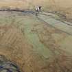
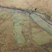
This farmstead, which lies on a terrace on the NE flank of Toft Knowes, comprises two buildings and a enclosure. The building, which has rounded ends and opposed entrances, measures 12.7m from ENE to WSW by 4m transversely within earthen banks 0.8m in thickness and 0.25m in height. The second building lies near the edge of the terrace and is a smaller structure, measuring about 9m in length by 3.5m in breadth overall (NY 4952 9569); it has a midden heap beside it. To the NE, on the edge of the terrace, there are several quarry pits (NY c.4962 9579).
(LID96 236)
Visited by RCAHMS (PJD) 17 April 1996

