
Toft Knowes


Pit (Post Medieval), Settlement (Later Prehistoric)
Site Name Toft Knowes
Classification Pit (Post Medieval), Settlement (Later Prehistoric)
Canmore ID 161995
Site Number NY49NE 22.01
NGR NY 4981 9553
Datum OSGB36 - NGR
Permalink http://canmore.org.uk/site/161995


- Council Scottish Borders, The
- Parish Castleton
- Former Region Borders
- Former District Roxburgh
- Former County Roxburghshire
Field Visit (17 April 1996)
NY49NE 22.01 4981 9553
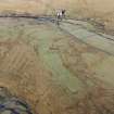
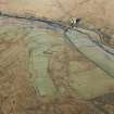
This settlement is situated on the gently sloping E flank of Toft Knowes, it measures 58m from NNE to SSW by 46m within a stony bank spread to 3.5m in thickness and 0.6m in height. The entrance is on the NE. A stony ban extends across the interior from E to W, dividing it intotwo unequal portions, and a gap midway along its course was presumably to allow access from one side to the other. Two stones are set upright about 1.2m apart on an axis from N to S in the NE corner of the S portion of the interior (NY 4983 9553); each is about 0.35m square in section and 0.5m in height. The W side of the settlement is overlain by one of the banks of the field-system (NY49NE 22.03).
Immediately S of the settlement there is a long narrow pit, with a dog-leg to the N towards the ENE end. It is flanked with upcast on either side and its floor, which is accessible from the WSW, is graded into the ground towards the ENE. It cuts through the bank of one of the fields of the surrounding field-system.
(LID96 237).
Visited by RCAHMS (PJD) 17 April 1996

