
Side


Boundary Ditch(S) (Medieval), Farmstead (Medieval), Field System (Medieval), Lazy Beds (Medieval), Rig And Furrow (Medieval), Sheepfold (Medieval), Tower (Medieval)
Site Name Side
Classification Boundary Ditch(S) (Medieval), Farmstead (Medieval), Field System (Medieval), Lazy Beds (Medieval), Rig And Furrow (Medieval), Sheepfold (Medieval), Tower (Medieval)
Alternative Name(s) Kirk Hill
Canmore ID 67875
Site Number NY48NE 6
NGR NY 4633 8582
Datum OSGB36 - NGR
Permalink http://canmore.org.uk/site/67875


- Council Scottish Borders, The
- Parish Castleton
- Former Region Borders
- Former District Roxburgh
- Former County Roxburghshire
NY48NE 6 4633 8582
(NY 4633 8582) Side Tower (NR) (Site of)
OS 6" map (1957)
This spot was pointed out by two local informants in 1858 as the site of Side Tower, which belonged to the Armstrongs, and in which lived "Jock o' the Side", well known in Border Ballads.
Name Book 1858
Jeffrey (1864) notes that the site is marked by a solitary ash tree and a few grass-grown mounds.
Armstrong refers to the house of Jock Armstrong of the Side, stating that no trace of it remains, though not far beyond living memory a score of tenanted houses stood here, forming the hamlet of Side. The foundations of these cottages are still plainly visible.
W A Armstrong 1960
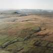
There is no evidence of this alleged tower and no trace of building foundationsin the indicated area. The hillslope is heavily mutilated by eroded river channels, drainage ditches and banks; the two amorphous, turf-covered stony mounds are at NY 4635 8583. Dr Robson (Hawick Museum) has no documentary record of a tower at Side and he says that Jock o' the Side's house was the Puddingburn Tower (NY48NE 5).
Visited by OS (MJF) 20 August 1979
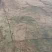
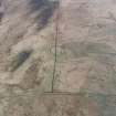
A field-system marked by pecked lines is depicted on the 1st edition of the OS 6-inch map (Roxburghshire 1862-3, sheet xlv), but it is not shown on the current edition of the OS 1:10000 map (1982).
Information from RCAHMS (SAH) 2 August 2000
Field Visit (13 November 1996)
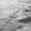
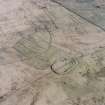
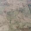
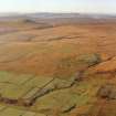
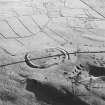
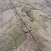
Nothing can be seen of a tower amongst the remains of this farmstead, which is situated on a terrace on a SE-facing hillside. The farmstead comprises at least three buildings, a kiln-barn and a complex of small enclosures, all overgrown with grass and rushes, at the centre of which there stands a disused circular sheep stell. To the W of the farmstead there are two substantial boundary ditches, each with fragments of an upcast bank on its inner (downhill) edge, which appear to represent successive phases of enclosure of the hillside. One of the ditches runs through the farmstead, which it appears to predate as two buildings (LID96 46-7) stand on the line of the upcast bank. The second ditch, farther up the hill to the NW, appears to represent an expansion of the enclosed ground to occupy the gap between the enclosures on Sufficient Hill, to the SW (NY48NE 144.00), and Kirk Hill, to the NE (NY48NE 145). The later ditch at Side abuts the boundaries of these other enclosures.
Within the area enclosed by these boundary ditches a system of subrectangular fields takes in about 6ha. The fields are defined by earthen banks and contain traces of rig cultivation with a 'reverse-S' form.
The largest of the farmstead buildings (LID96 46) measures 12.6m in length and splays from 3.8m in breadth at the SSE end to 4.5m on the NNW within a turf wall 0.5m high and spread to 1.3m in thickness. There may be the remains of an enclosure on its NE side and 20m to the E there is a large grass-grown mound that may be a midden heap. The other two buildings (LID96 47-8) are considerably smaller, measuring respectively 6.7m by 3.5m and 8.3m by 2.9m within walls constructed largely of turf and standing no more than 0.3m high. The kiln-barn (LID96 49) comprises a bowl set into the hillside on the NNW with the fragmentary remains of the barn on a platform on the uphill side. The bowl measures 2.5m in diameter and 0.5m in depth and a gap on the SSE indicates the position of the flue; the barn measures 4.2m by 3m within a stony bank 0.8m thick. Around the farmstead there are about ten small subrectangular enclosures, amongst which there may be fragments of other buildings. Two of the enclosures, at the S edge of the site, contain lazy-bed cultivation.
(LID96 46-9)
Visited by RCAHMS (SDB) 13 November 1996
Sbc Note (21 March 2016)
Visibility: This was the site of an archaeological monument, which may no longer be visible.
Information from Scottish Borders Council

