
Ewesdale - Ewes Doors - Wrangway Burn, Old Road


Hollow Way(S) (Medieval) - (Post Medieval), Road (Medieval) - (Post Medieval), Roman Road (Roman)(Possible)
Site Name Ewesdale - Ewes Doors - Wrangway Burn, Old Road
Classification Hollow Way(S) (Medieval) - (Post Medieval), Road (Medieval) - (Post Medieval), Roman Road (Roman)(Possible)
Canmore ID 115210
Site Number NY39NE 29
NGR NY 386 950
NGR Description NY c. 386 950 to NY c. 377 999
Datum OSGB36 - NGR
Permalink http://canmore.org.uk/site/115210


- Council Dumfries And Galloway
- Parish Ewes
- Former Region Dumfries And Galloway
- Former District Annandale And Eskdale
- Former County Dumfries-shire
NY39NE 29 c. 386 950 to c. 377 999
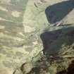
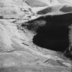
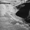
The presence of the Roman watch tower NY39NE 4 in the pass of the Ewes Doors (on the watershed between the valleys of the Eweslees and Wrangway Burns) suggests that a Roman road may have followed approximately the same line as the old road running via Eweslees to Caerlanrig (NT30SE 10) that passes immediately to its N.
The course of this road can be readily traced as a low metalled terrace or agger running through the enclosures (NY39NE 14) to the N of the Ewes Burn from Eweslees farmstead (NY39NE 25), but, as it climbs WNW from the floor of Eweslees Hope, its line is marked by a series of broken hollow-ways interdigitated between the renants of at least two later, well-engineered, metalled terrace-ways. Here and there, however, traces of metalling can also be detected on the crests between the hollow-ways and at the margins of the later roadways. Although these fragments appear to be the earliest in the sequence, it is by no means certain that they date from as far back as the Roman period.
A Roman road running N from Broomholm fort (NY38SE 7) could have followed the course of the Lower Esk before branching up the Ewes Water and dropping down into the head of Teviotdale. The Eweslees to Caerlanrig road was replaced by the turnpike from Langholm to Hawick (now the A7 public road) in 1765.
Visited by RCAHMS (SPH, ATW), 17 December 1996.
OSA 1795; RCAHMS 1956.
Note (10 March 1997)
NY c. 386 950 to c. 377 999 NY39NE 29
This road may have run from Ewesdale (NY c. 386 950) to Wrangway Burn (NY c. 377 999) through intermediate points at Eweslees (NY c. 388 972) and Ewes Doors (NY 382 976) across the parishes of Ewes (Dumfries and Galloway) and Teviothead (Scottish Borders).
Information from RCAHMS (RJCM, ATW), 10 March 1997.
Listed as part of possible Broomholm - Ewesdale - Ewes Doors Roman road, for which see also NY38SE 89.
RCAHMS 1997.

