
Scheduled Maintenance
Please be advised that this website will undergo scheduled maintenance on the following dates: •
Tuesday 3rd December 11:00-15:00
During these times, some services may be temporarily unavailable. We apologise for any inconvenience this may cause.
Broomholm


Palisaded Settlement (Prehistoric), Roman Fort (Roman)
Site Name Broomholm
Classification Palisaded Settlement (Prehistoric), Roman Fort (Roman)
Alternative Name(s) Broomholm Knowe; Broomholmshiels
Canmore ID 67709
Site Number NY38SE 7
NGR NY 3786 8145
Datum OSGB36 - NGR
Permalink http://canmore.org.uk/site/67709


- Council Dumfries And Galloway
- Parish Langholm
- Former Region Dumfries And Galloway
- Former District Annandale And Eskdale
- Former County Dumfries-shire
Remains of Roman fort overlying an earlier non-Roman defensive structure. Located on summit of Broomholm Knowe within semi-improved land. Distant views in most directions, particularly along Esk valley to north and south. Other Roman fort located to the south
information from Héléna Gray, (CFA Archaeology Ltd), August 2015
NY38SE 7 3786 8145
See also NY38SE 89.
(NY 3781 8140) ROMAN FORT (R) (Remains of)
OS 6" map (1957)
This fort was discovered in 1950 by R W Feachem and since excavated by C M Daniels of Newcastle University and A E Truckell. It is of three periods, Flavian I, Flavian II, and possible Hadrianic, over an earlier ditch with large boulders perhaps toppled from a native rampart. Occupation earlier thought to be Antonine now seems unlikey.
Flavian I: Two ditches surround the 22 ft turf rampart of a fort c. 575 ft by 325 ft, with S annexe 360 ft by 200ft.
Flavian II: Found with certainty on S. An undated ditch on N, if belonging to this period, would define an area 680 ft long.
Perid III: The final fortlet measured 325 ft by 270 ft with a ditch 14 ft wide and 4 ft deep (D R Wilson 1965).
The excavation revealed hearths, and pottery, glass and cereal grains were found, while G Macdonald (1918) mentions six gold coins (3 Nero, 2 Vespasian and 1 Domitian) from here. Elsewhere in the field are ancient roads and field banks. Roads which pass either side of the fort were sectioned. That on the W proved to be 18th century; the one on the E is much older and has been destroyed in places by early modern and medieval works. (Visible on APs 541/RAF/A/524 F20:3141-2)
NSA 1841 (W B Shaw and W Brown); R W Feachem 1950; 1951; Trans Dumfriesshire Galloway Natur Hist Antiq Soc 1962; A E Truckell 1956; 1960; D R Wilson 1962; 1963; J Roman Stud 1957
The native occupation, represented by traces of post-holes and ditches underlying the Flavian I rampart on the E side, seems to have been levelled by the Flavian I fort. This in its turn was dismantled, as its N gate showed. The Flavian II fort probably followed after a short delay, and the final occupation of the site, the Hadrianic fortlet, ended in destruction, although details of its date and duration are obscure.
C M Daniels TS. Report 1964 (NMRS MS/324).
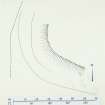
Centred NY 3786 8145. The denuded remains of this Roman fort lie on the southerly slopes of Broomholm Knowe at 122m OD. The SW corner is the principal surviving feature and comprises a 1.5m high scarp with a double bank and ditch; this however, has been mutilated, possibly by the excavation. The easterly extent of the work is defined by steep natural slopes and there is no surface evidence of a bank or ditch.
A 160.0m long, 0.5m deep ditch indicates the western limit of the fort; however, it is not possible to deduce which of the ditches this represents. This is similarly the case with two 0.4m deep ditches which run along the N side and are roughly parallel with the approximate line of the S side which is indicated by a scarp.
The hillslope has been extensively cultivated and there are numerous drainage ditches in addition to the courses of the old roads and a large man-made pond; these factors make ground interpretation of the site very difficult.
Surveyed at 1:2500.
Visited by OS (MJF) 5 October 1979
Field Visit (16 August 1950)
This site was included within the RCAHMS Marginal Land Survey (1950-1962), an unpublished rescue project. Site descriptions, organised by county, are available to view online - see the searchable PDF in 'Digital Items'. These vary from short notes, to lengthy and full descriptions. Contemporary plane-table surveys and inked drawings, where available, can be viewed online in most cases - see 'Digital Images'. The original typecripts, notebooks and drawings can also be viewed in the RCAHMS search room.
Information from RCAHMS (GFG) 19 July 2013.
Reference (1957)
This site is noted in the ‘List of monuments discovered during the survey of marginal land (1951-5)’ (RCAHMS 1957, xiv-xviii).
Information from RCAHMS (GFG), 24 October 2012.
Excavation (1964)
The native occupation, represented by traces of post-holes and ditches underlying the Flavian I rampart on the E side, seems to have been levelled by the Flavian I fort. This in its turn was dismantled, as its N gate showed. The Flavian II fort probably followed after a short delay, and the final occupation of the site, the Hadrianic fortlet, ended in destruction, although details of its date and duration are obscure.
C M Daniels TS. Report 1964 (NMRS MS/324).
Field Visit (August 1980)
Broomholm NY 378 814 NY38SE 7
Situated on the summit of Broomholm Knowe, about 500m SSW of Broomholmshiels farmhouse, there are the denuded remains of a Roman fort, which excavation has shown to have been occupied at least twice between AD 80 and 120. In the earlier, or Flavian, period the fort measured about 175m by 100m (1.8ha) over the rampart, with an annexe 0.7ha in area attached to its S side; both structures were initially enclosed by at least two ditches, but a third and possibly a fourth ditch appear to have been added subsequently. On all sides but the SE the remains of the Flavian defences may still be traced on the ground, the best-preserved portion being on the SW. There are, however, no visible traces of the small fort which eventually succeeded the earlier works; measuring about 100m by 82m (0.8ha), it appears to have occupied the S half of the original fort site. The excavation also revealed traces of an enclosed prehistoric settlement on the site before the Roman occupation, and a round house was built in the fort after it had been abandoned.
RCAHMS 1981, visited August 1980
(Feachern 1950; DES, 1956, 13-14; Journal of Roman Studies, xlvii, 1957, 201; Iii 1962, 164; liii, 1963, 128; Iv, 1965, 202)
Note (1997)
NY 3786 8145 NY38SE 7
Listed as fort.
RCAHMS 1997.
Project (29 May 2014)
An archaeological evaluation was undertaken by CFA Archaeology Ltd, a desk based assessment and walk over survey (May 29th 2014) was conducted
The historic environment record within the Site Boundary is relatively limited, although there is some potential for the proposed development site to contain previously unknown heritage assets from at least the later prehistoric period onwards, given the historic landscape character of the wider area. Taking this into account, the archaeological potential of the proposed development site is considered to be low.
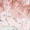
A summary assessment, on a site by site basis, of the predicted effects on the settings of assets within a 10km radius where the blade tip ZTV indicates that there would be theoretical views of one or more turbines
information from Héléna Gray, (CFA Archaeology Ltd), August 2015
OASIS ID: cfaarcha1-278420

