
Tarras Water


Lade (17th Century) - (18th Century)
Site Name Tarras Water
Classification Lade (17th Century) - (18th Century)
Alternative Name(s) Cronksbank; Howgillcleuch; Byreburnfoot
Canmore ID 67681
Site Number NY38SE 38
NGR NY 3937 8311
NGR Description NY39568429 to NY 3948 8120
Datum OSGB36 - NGR
Permalink http://canmore.org.uk/site/67681


- Council Dumfries And Galloway
- Parish Canonbie
- Former Region Dumfries And Galloway
- Former District Annandale And Eskdale
- Former County Dumfries-shire
Field Visit (February 1981)
Byreburnfoot NY37NE
From NY 395 840 to 392 817, there is the remains of a lade which probably supplied the water bucket engine associated with the coal mine NY37NE 34.
RCAHMS 1981, visited January 1981.
Field Visit (2 March 1994)
NY38SE 38 NY 3929 8158 - 3979 8457
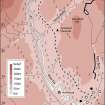
The remains of this lade extend for a distance of 3km, running S from Cronksbank Cottage (NY38SE 74.01) as far as Howgillcleuch (NY38SE 76). The lade fed a small reservoir which is located some 350m to the SW of Howgillcleuch, and from here the water was carried S by a straight length of ditch and into a tributary of the Byre Burn. There is no doubt that the lade was fed from the Tarras Water, although the precise take-off point is uncertain; the first visible traces of the lade currently stand about 2m above the present water level. A short length of a retaining wall is also visible along the river bank at this point. The course of the lade generally follows the line of the 130m OD contour and its state of preservation varies considerably. Where best-preserved, it comprises a well-defined ditch with a retaining bank on its downslope side, but along other stretches it has been reduced to little more than a narrow terrace, and, in two places, it falls within later fields and has been ploughed-out. At several points the retaining bank has been revetted, and the stone abutments for the timber troughs that carried the lade across the gullies of the Raegill Burn and the How Gill can still be seen. The lade is said to have supplied the water to operate the water-bucket pumping-engine and winding water wheels for the coal-workings at Byreburn (NY37NE 34.00) and its course is shown on a map of Canonbie parish produced for the Buccleuch estate in 1810 (for which, see NY37NE 34).
Visited by RCAHMS (ARW, JRS), 2 March 1994.
Tarras Water. Listed as lade.
RCAHMS 1997.

