
Carthur Hill


Fort (Prehistoric)
Site Name Carthur Hill
Classification Fort (Prehistoric)
Alternative Name(s) Boreland
Canmore ID 66925
Site Number NY19SE 10
NGR NY 18402 94029
Datum OSGB36 - NGR
Permalink http://canmore.org.uk/site/66925


- Council Dumfries And Galloway
- Parish Hutton And Corrie
- Former Region Dumfries And Galloway
- Former District Annandale And Eskdale
- Former County Dumfries-shire
NY19SE 10 1838 9403.
(NY 1838 9403) Fort (NR)
OS 6"map, (1958)
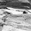
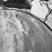
A fort, some 210' by 120', longest axis NE-SW. On the NW a stony rampart, formed in part by cutting away the interior of a narrow ridge of rock, was apparently surmounted by a wall, the whole about 11' high. On the exterior, a shoulder about 5' from the crest divides into two distinct gradients, the upper probably encumbered with wall debris. An entrance at the SE opens into a hollow which appears to have been excavated. Behind the hollow is a circular depression, 34' by 28', cut out of rock on the upper side, while to the right of the hollow, a slight ridge indicates an oval foundation, probably of a hut circle. There may have been a second entrance by a ramp a little SE of the first.
RCAHMS 1920
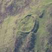
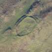
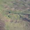
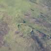
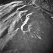
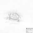
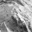
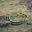
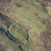
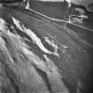
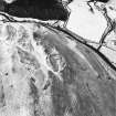
On top of Carthur Hill is an oval fort measuring internally 57.0m NE-SW by 34.0m transversely within the remains of an earth-and-stone rampart, best preserved on the W side where it measures 6.0m wide and up to 1.8m high. On the SE where the rampart followed the top of a steep natural slope, it has been severely denuded, and in the NE and NW are the unsurveyable traces of an outer ditch. In the NW a terrace follows the rampart for c. 40m. The entrance is in the SW. A probable house platform occupies the centre of the fort, and measures 11.0m N-S by 9.0m transversely. There are possible sites of three others in the interior. Two small quarries 30m N of the site probably supplied some of the material for the ramparts.
Resurveyed at 1:2500.
Visited by OS (D W R) 20 March 1972
Listing this site among 'Non-defensive settlements with round timber-built huts', Jobey adds, 'Though situated at altitude, on a shelf, there is no real pretence at defence in the artificial perimeter.'
G Jobey 1971
This fort is as described in previous field report.
Surveyed at 1:10,000.
Visited by OS (J R L) 22 September 1978.
Measured Survey (4 September 1990)
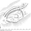
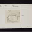
RCAHMS surveyed the fort at Carthur Hill on 4 September 1990 with plane-table and self-reducing alidade at a scale of 1:500. The plan was redrawn in ink and published at a scale of 1:1000 (RCAHMS 1997, Fig. 138).
Field Visit (4 September 1990)
NY 1838 9403 NY19SE 10
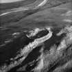
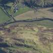
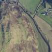
The remains of this fort are situated on a rocky knoll at the E end of a broad ridge overlooking the valley of the Dryfe Water. Oval on plan, it measures 54m from NE to SW by 33m transversely within a wall reduced to a grass-grown stony bank up to 5m in thickness and 1.1m in internal height. An external ditch extends along the bottom of a natural gully around the NW half of the perimeter, petering out on the steep slope to the SW, but ending ubruptly on the N at the foot of the rocky ridge that forms the SE side of the gully. A further segment of ditch is visible to the SE of the ridge on the ENE of the fort. On the SW, opposite the entrance, the ditch is broken by a causeway, and a low external mound at the S ditch terminal may be all that remains of a counterscarp bank.
Within the fort, several terraces and artificial platforms indicate the position of timber round-houses. At the centre of the interior a large platform, measuring about 9m in diameter, has been dug into the slope on the N and is partly enclosed by a grass-grown bank around the S; the entrance is on the W. Two more platforms, the better defined measuring about 8m in diameter, lie to the NE of the central house, and another, which measures about 11m in overall diameter, lies to the SW. A small rectilinear scoop impinges on the bank of the central house on the SE.
Visited by RCAHMS (JRS, SF) 4 September 1990.
Listed as defended settlement.
RCAHMS 1997.
Note (13 June 2014 - 23 May 2016)
This fort is situated in an unlikely position on the lip of a steep hill-side dropping down to W bank of the Dryfe Water. Oval on plan, the interior measures 54m from ENE to WSW by 33m transversely within a stone wall which has largely been reduced to a mound of rubble up to 5m in thickness by up to 1.1m in height. On the NNE, where there is also a short run of outer facing-stones, the wall mounts a rib of rock outcrop to significantly enhance its stature above a natural gully along the relatively weak NW flank. The defences have been further enhanced here with a ditch that has been dug back into the flank of the gully below the wall, and though this has not been cut through the rib of outcrop on the NNE, a further segment of ditch has been dug in front of the wall on the NE. The entrance is on the WSW, and a causeway has been left where the ditch swings round this end of the fort to peter out on the lip of the escarpment to the SE. Within the interior there are at least four house platforms, the best defined of which lies at the centre and measures about 9m in diameter; a small rectilinear scoop cuts into the bank that flanks this platform's southern side.
Information from An Atlas of Hillforts of Great Britain and Ireland – 23 May 2016. Atlas of Hillforts SC0982

