
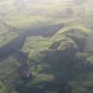
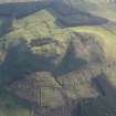
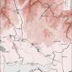
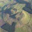
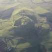
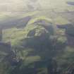
Burnswark


Cemetery (Early Medieval)(Possible), Enclosure(S) (Late Iron Age), Fortlet (Roman), Settlement (Late Iron Age), Track (Prehistoric)
Site Name Burnswark
Classification Cemetery (Early Medieval)(Possible), Enclosure(S) (Late Iron Age), Fortlet (Roman), Settlement (Late Iron Age), Track (Prehistoric)
Canmore ID 72884
Site Number NY17NE 2.03
NGR NY 1891 7867
Datum OSGB36 - NGR
Permalink http://canmore.org.uk/site/72884


- Council Dumfries And Galloway
- Parish Hoddom
- Former Region Dumfries And Galloway
- Former District Annandale And Eskdale
- Former County Dumfries-shire
Field Visit (29 March 1994)
NY17NE 2.03 1891 7867
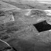
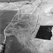
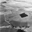
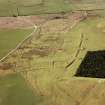
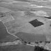
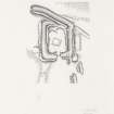
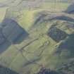
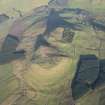
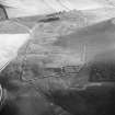
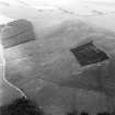
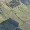
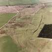
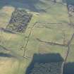
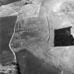
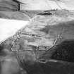
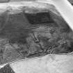
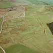
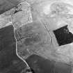
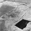
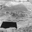
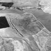
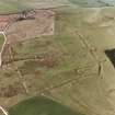
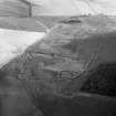
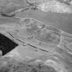
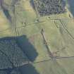
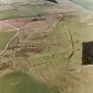
The remains of a second century Roman fortlet are situated on the S flank of Burnswark Hill below the large native hillfort (NY17NE 2.02) that crowns the summit of the hill. The fortlet underlies the rampart and ditch of a large Roman temporary camp (NY17NE 2.04) and is also overlain by the platforms of four timber round-houses and a possible Early Christian cemetery.
The fortlet measures about 30m from NW to SE by 19m transversely within a grass-grown rampart which measures up to 5m in thickness by 0.5m in height and is accompanied by an external ditch (5m broad and 1m deep) with a low counterscarp bank. The entrance is at the midpoint of the SE side. The perimeter of the later temporary camp runs obliquely up to the NW side of the fortlet, its rampart burying part of the fortlet ditch and ending in a rounded terminal on the N angle. The relationship of the fortlet with the NE side of the camp is less clear; the camp ditch appears to cut through the counterscarp of the fortlet ditch at the E angle, but there is no evidence that the NE defences of the fortlet were refurbished when they were incorporated into the camp.
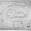
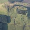
Within the NW part of the fortlet, at least two circular house-platforms about 10m in diameter are defined by well-preserved rear scarps. It is possible that these two are contemporary, but the NE platform appears to cut through the front of an earlier platform which has been set into the foot of the rampart of the temporary camp. A fourth platform, measuring about 7m in diameter within a rear scarp and a front apron, cuts into the outer face of the fortlet's counterscarp bank on the SW. During his excavation of the site, Barbour (Christison, et al, 1899) located several post-holes and interpreted them as the remains of two circular timber houses; his plan shows that they coincide with the two well-defined platforms that have been identified within the interior.
Close to the centre of the interior, there are also the remains of a small subsquare enclosure measuring about 7m across within a low bank. Interpreting the results of Barbour's investigation of the site, Jobey (1978) tentatively identified the enclosure as an enclosed early Christian burial-ground. Like many of the earthworks on the S side of the hill, this enclosure has suffered from animal erosion and from being driven over by tracked or large-wheeled vehicles, and it is barely visible today.
Outwith the NE side of the fortlet and tacked on to the outer face of the counterscarp bank, there are the remains of a possible enclosure. Subrectangular on plan, it measures 19.5m from NW to SE by 5m transversely within a shallow ditch up to 2m broad. A second enclosure, subsquare on plan and mutilated by recent disturbance, is situated at the E corner of the fortlet, within the angle formed by the junction of the outer face of the counterscarp bank and the ditch of the later temporary camp. It measures roughly 6m across internally and is clearly later than both the Roman earthworks.
Clearly earlier than the Roman earthworks, however, is a shallow trackway which approaches the N angle of the fortlet from the E, and disappears under the counterscarp bank.
Visited by RCAHMS (JRS), 29 March 1994.
(D Christison, J Barbour and J Anderson 1899; G Jobey 1978).
Listed as Roman fortlet and burial-ground (possible) at NY 1891 7867.
RCAHMS 1997.
Measured Survey (29 March 1994)
RCAHMS surveyed the Roman fortlet at Burnswark on 29 March 1994 with plane-table and self-reducing alidade at a scale of 1:500. The plan was redrawn in ink and published at a scale of 1:1000 (RCAHMS 1997, Fig. 194).

