
Pricing Change
New pricing for orders of material from this site will come into place shortly. Charges for supply of digital images, digitisation on demand, prints and licensing will be altered.
Gallaberry


Barrow(S) (Prehistoric), Cursus (Neolithic), Pit(S) (Period Unassigned), Square Barrow(S) (Iron Age)
Site Name Gallaberry
Classification Barrow(S) (Prehistoric), Cursus (Neolithic), Pit(S) (Period Unassigned), Square Barrow(S) (Iron Age)
Alternative Name(s) West Gallaberry
Canmore ID 65861
Site Number NX98SE 51
NGR NX 96473 82815
Datum OSGB36 - NGR
Permalink http://canmore.org.uk/site/65861


- Council Dumfries And Galloway
- Parish Kirkmahoe
- Former Region Dumfries And Galloway
- Former District Nithsdale
- Former County Dumfries-shire
NX98SE 51 96470 82817
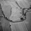
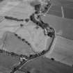
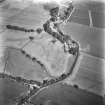
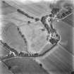
'A preliminary resistivity survey, in the form of several traverses, was made at this site which is known from aerial photographs and some exploratory excavation. Good anomolies were obtained on the line of the cursus.'
J Williams and G Anderson 1971
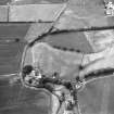
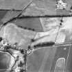
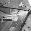
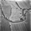
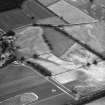
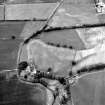
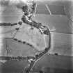
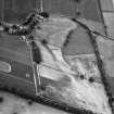
The parallel ditches of a possible cursus monument are visible on aerial photographs running NE from the Roman Temporary Camp (NX98SE 4) at Gallaberry across gently undulating ground. No terminals can be seen but the ditches run for a distance of at least 400m and are about 35m apart. Given that the ground drops sharply to the SW, it seems likely that the cursus would not have extended much further in this direction, and the SW terminal is probably masked by the steading of West Gallaberry farm (NX98SE 69).
Information from RCAHMS (ARG), 7 April 1998
Aerial Photographic Transcription (8 June 2012)

