
Curriestanes


Cursus (Neolithic)
Site Name Curriestanes
Classification Cursus (Neolithic)
Canmore ID 65621
Site Number NX97NE 85
NGR NX 95990 75170
Datum OSGB36 - NGR
Permalink http://canmore.org.uk/site/65621


- Council Dumfries And Galloway
- Parish Troqueer (Kirkcudbrightshire)
- Former Region Dumfries And Galloway
- Former District Nithsdale
- Former County Kirkcudbrightshire
NX97NE 85 95990 75170
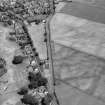
Nothing can now be seen of this cursus monument, which was first discovered by aerial photography. It lies on gently undulating ground to the E of Curriestanes farm, on the SW outskirts of Dumfries. Defined by an irregular ditch, to date only the E end has been photographed, but the cursus measures at least 300m from E to W by up to 95m overall, narrowing to about 70m at the terminal. At the terminal, the angles are markedly rounded and a causeway across the ditch about 6m wide is clearly visible on the axis of the cursus. The cursus monument is plotted on a distribution map of Neolithic monuments covering southern Scotland (RCAHMS 1997, 115, fig. 110).
Information from RCAHMS (ARG), 7 April 1998
Aerial photography has revealed the cropmarks of a cursus running W-E from Curriestanes house for at least 300m. The N side is visible from NX 9591 7522 to NX 9613 7518, and is intersected by a modern road. The S side can be traced from NX 9583 7512 to NX 9613 7517, and they curve towards a rounded terminal at the E end. A possible entrance about 10m wide lies in the centre of the terminal, and the cursus is 95m wide. The ditches vary in width from 2m to 5m and are very irregular, suggesting that they were constructed in short segments rather than as part of one unitary construction, a feature of many cursus sites in Scotland (Armit 1993).
Information from RCAHMS (KB) 20 April 1999
NX 956 752 A watching brief was undertaken in September and October 2002 on the laying of a new sewer pipeline along the S verge of Park Road, Maxwellton, Dumfries. Park Road obliquely bisects Curriestanes Cursus, which is one of a cluster of cursus monuments that have been identified by aerial reconnaissance in Nithsdale.
Archaeological monitoring of topsoil stripping in advance of the pipe-laying operations revealed the N and S boundary ditches of the cursus. The southern ditch survived c 5m wide and 0.6m deep, and the northern ditch c 2.5-3.m wide and 0.65m deep. There had clearly been truncation of the ditches and the surface of the gravel subsoil by modern road construction. Excavation of the ditch fills produced no finds, and sampling was not pursued due to extensive contamination from adjacent pipe and cable trenches running along the road verge.
The only other archaeological feature encountered was a small truncated pit located in the interior of the cursus. Its fill contained c 20 fragments of a single Beaker-type vessel, decorated with lines of impressed twisted cord and rows of fingernail impressions. A radiocarbon date of 3875±45 years BP was obtained from oak charcoal from the fill of the feature. Small fragments of burnt bone were also recovered from the feature.
Full report lodged with Dumfries and Galloway SMR and the NMRS.
Sponsor: Morgan Est plc.
M L Brann 2003
NX 958 751 A programme of archaeological investigative works was undertaken on 16 February 2007 in respect of the
proposed development on land at Pearmont House, Dumfries. The evaluation comprised four trenches covering approximately 5% of the development area. The site lies close to or within the site of a cursus monument (DG6082; NX 97NE85) noted on aerial photographs of the area. No sign of the cursus was found within the evaluation area. All four trenches exhibited a fairly common stratigraphic sequence with a mid to light brown fine silty/sand topsoil up to 300mm deep, overlying a distinct homogenous orange/brown silty/sand with frequent sub angular stones throughout, extending in depth beyond 1.2m. No significant archaeological features were identified.
Report deposited with Dumfries and Galloway Archaeology Service and archive with RCAHMS.
Funder: Ian Watson.
Claire Shaw, 2007.
Aerial Photographic Transcription (22 November 1990 - 1 February 1991)
An aerial transcription was produced from oblique aerial photographs. Information from Historic Environment Scotland (BM) 31 March 2017.
Archaeological Evaluation (16 February 2007)
NX 958 751 A programme of archaeological investigative works was undertaken on 16 February 2007 in respect of the proposed development on land at Pearmont House, Dumfries. The evaluation comprised four trenches covering approximately 5% of the development area. The site lies close to or within the site of a cursus monument (DG6082; NX 97NE85) noted on aerial photographs of the area. No sign of the cursus was found within the evaluation area. All four trenches exhibited a fairly common stratigraphic sequence with a mid to light brown fine silty/sand topsoil up to 300mm deep, overlying a distinct homogenous orange/brown silty/sand with frequent sub angular stones throughout, extending in depth beyond 1.2m. No significant archaeological features were identified.
Report deposited with Dumfries and Galloway Archaeology Service and archive with RCAHMS.
Funder: Ian Watson.
Aerial Photographic Transcription (31 May 2012)
Watching Brief (19 August 2014)
NX 9599 7517 (centred on) A watching brief was undertaken on 19 August 2014 in advance of the replacement of two electricity poles within the area of the scheduled monument. Trench 1 (NX 96005 75202) was excavated through recent backfill deposits and was archaeologically sterile. In Trench 2 (NX 95985 75121) a natural boulder clay surface, sealed by plough zone and modern backfill deposits, was recorded at a depth of c0.35m. There were no finds or features of archaeological significance.
Archive: Dumfries and Galloway Council, Historic Scotland and
RCAHMS (intended)
Funder: CIET (UK) Ltd
John Pickin
(Source: DES)
OASIS ID: johnpick1-188193

