
Milton Loch


Crannog (Period Unassigned)
Site Name Milton Loch
Classification Crannog (Period Unassigned)
Alternative Name(s) Milton Loch 3
Canmore ID 72519
Site Number NX87SW 15
NGR NX 8394 7149
Datum OSGB36 - NGR
Permalink http://canmore.org.uk/site/72519


- Council Dumfries And Galloway
- Parish Urr
- Former Region Dumfries And Galloway
- Former District Stewartry
- Former County Kirkcudbrightshire
NX87SW 15 8394 7149
See also NX87SW 4 and NX87SW 5.
Underwater examination of this conspicuous island in the middle of Milton Loch revealed it to be a crannog with piles and transverse timbers, from which samples were taken on behalf of, and funded by SDD (HBM).
T N Dixon 1989.
As the underwater component of Phase 2 of the South West Crannog Survey, the state of preservation of 14 crannog sites was evaluated in 12 lochs throughout Dumfries and Galloway as part of the Scottish Wetland Archaeology Programme (SWAP).
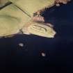
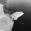
NX 8394 7149 Milton Loch III (NX87SW 15). This site is an artificial enhancement of a natural bedrock outcrop, which sits at the end of a promontory extending out from the W shore of the loch. It has a total diameter of c 30m. Boulders, piles and horizontal timbers were observed around the N and NW edges of the site. As with the previous two sites, these timbers showed evidence of degradation due to biological activity.
Sponsors: HS, Scottish Trust for Archaeological Research, AOC Archaeology Group, University of Nottingham
M G Cavers and J C Henderson 2002.
Milton Loch 3 (Urr catchment): location cited as NX 8428 7149.
This crannog was discovered in 1989, when two piles were sampled for radiocarbon dating. These yielded determinations of 1470 +/- 50 bp [480 ad] (GU-2645) and 1460 +/- 70 bp [490 ad] (GU-2646).
The crannog was surveyed in July 2002 during the 2nd phase of the South-West Scotland Crannog Survey, with the intention of establishing an effective system of monitoring the rate of organic decay. Given the evidence noted for biological activity, it was considered a candidate for continued monitoring.
This crannog is situated on a natural outcrop of bedrock at the end of a promontory projecting from the W side of the loch. It appears above water as a tree-covered island measuring about 20m in diameter, and shelves away underwater to depths of between 2 and 3m, the basal diameter being about 30m over all. The occurrence of boulders, piles and transverse timbers underwater indicates that the mound is mainly of artificial construction. However, in places boulders sit on naturally outcropping bedrock, suggesting that the artificial mound is an enhancement of a natural feature. Piles (several of which retained their bark) were noted on the NW margins of the monument, while horizontal oak timbers projected from several parts of the mound.
The mound is choked with aquatic plants, while all the exposed wood was being actively eroded by worms and infested with algae.
J C Henderson, B A Crone and M G Cavers 2003.

