
Greenlaw


Earthwork(S) (Period Unassigned), Enclosure (Period Unassigned), Tower House (Medieval)(Possible), Cannon Ball
Site Name Greenlaw
Classification Earthwork(S) (Period Unassigned), Enclosure (Period Unassigned), Tower House (Medieval)(Possible), Cannon Ball
Alternative Name(s) Wheatcroft; Greenlaw Tower; Fortalice Of Greenlaw; Mains Of Greenlaw, Castle Earthworks; Black Bridge
Canmore ID 64700
Site Number NX76SW 9
NGR NX 7409 6355
Datum OSGB36 - NGR
Permalink http://canmore.org.uk/site/64700


- Council Dumfries And Galloway
- Parish Crossmichael
- Former Region Dumfries And Galloway
- Former District Stewartry
- Former County Kirkcudbrightshire
NX76SW 9.00 7409 6355.
(NX 7409 6355) Tower and Fortalice of Greenlaw (NR) (Site of)
OS 6" map (1946).
NX76SW 9.01 NX 7406 6355 Buildings; Enclosure
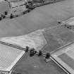
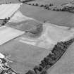
The outworks of a defended site are all that now remain of this fortalice. On plan it consists of a rough oblong or ellipse with the main axis running from northeast to south-west, and measuring some 440 feet by 310 feet within the continuous ditch and rampart which encircle it, excepting to the south-east where the inner rampart is almost obliterated. A level rampart or terrace some 40 feet wide bounds the whole length of the south-east side, the outer line being clearly defined by a scarp which curves toward a small pond at the south-west where it merges into the river bank. Indications of an entrance can still be seen, in the centre of the north-eastern line of defences, which, owing to the marshy nature of the surrounding ground, appears to have been approached by a raised causeway from the north-east.
At the site of a castle indicated by the Ordnance Survey, only a modern cottage and a few inequalities in the surface of the ground remain.
RCAHMS 1914
Greenlaw was a residence at the Reformation. Rebuilding was commenced between 1735 and 1741. Reid shows a plan and view on which the main buildings may be fairly accurate but the surrounding wall and gatehouse are problematical. The architectural style is 17th century.
R C Reid 1925
The outworks of the site are generally as described by RCAHMS. The bank or rampart enclosing the site is best preserved at the N, W, E angles; elsewhere it is reduced to a mere scarp, and it fades out entirely on the on the south side. The ditch is fairly well preserved except on the south west side where it has been obliterated. It has an average width of 7.0-8.0m and an average depth of 0.6m. A broad terrace 10m in width runs along the whole south-east side merging into a modern flood-bank. No trace of any building foundation other than modern, were seen within the enclosing rampart. No trace of a causeway was seen on the north-east side.
Revised at 25".
Visited by OS (WDJ) 19 January 1963.
An expanse of relatively level ground under open pasture to the W of Wheatcroft farmsteading, and close to the haughland of the River Dee, has been enclosed by a bank with an external ditch and a counterscarp bank. These are believed to be the remains of the outworks of Greenlaw Tower, of which nothing is now visible.
The enclosure, which is roughly suboval on plan, has been truncated on the N by the realignment of the farm track, while the E arc has been reduced to little more than a slight swelling in the surface of the field. The enclosing bank is up to 6m thick and 0.6m high, the ditch 4m wide and 0.9m deep, and the counterscarp bank 1.5m thick and 0.3m high. On the W, several sections of masonry, two to three courses high, may represent the remains of an external masonry revetment to the bank. There is no evidence of an entrance-causeway.
Some ten years ago, an iron canonball was discovered by the farmer in an eroded exposure on the NE arc of the earthwork.
Visited by RCAHMS (IMS/JRS) 6 September 1993.

