
Glenlochar


Temporary Camp (Roman)
Site Name Glenlochar
Classification Temporary Camp (Roman)
Alternative Name(s) Glenlochar 3; Montford
Canmore ID 64696
Site Number NX76SW 5
NGR NX 73900 64240
NGR Description Centred NX 7390 6424
Datum OSGB36 - NGR
Permalink http://canmore.org.uk/site/64696


- Council Dumfries And Galloway
- Parish Crossmichael
- Former Region Dumfries And Galloway
- Former District Stewartry
- Former County Kirkcudbrightshire
NX76SW 5 centred 73900 64240
(NX 7390 6425) Roman Marching Camp (R) (Site of)
OS 6" map (1957).
See also NX76SW 4.
This camp is part of a complex of forts and camps at Glenlochar, ? Agricolan to Antonine.
Information from J K St Joseph 1949; J K St Joseph 1951; J K St Joseph 1958.
There is no trace of this camp to be seen on the ground.
Surveyed from St Joseph AP and ground observation.
Visited by OS (RD) 30 July 1968.
Roman Camp
(site of) [NAT] (at NX 7383 6421)
OS (GIS) MasterMap, March 2011.
Scheduled (with NX76SW 2-4, 6, 23, 24 and 29) as 'Glenlochar, Roman fort, annexe, road, camps and barrows 50m E of Montford....'.
Information from Historic Scotland, scheduling document dated 1 March 2011.
Publication Account (17 December 2011)
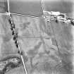
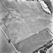
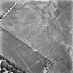
A series of camps has been recorded outside the Roman fort at Glenlochar on the east bank of the River Dee, all discovered as cropmarks by St Joseph in 1949 (1951a: 60– 1). Excavations at the fort have identified three phases: one Flavian and two Antonine, with a further earlier Flavian (Agricolan) fort suspected just to the north of the main fort site (Richmond and St Joseph 1953).
At least five camps are known at Glenlochar, one (V) exhibiting an annexe with an internal partition. St Joseph recorded a further possible two-phase camp in the interior of camp I (Glenlochar VI, see St Joseph 1958: 89; RCAHMS St Joseph Collection: DC 37387–8; and below, possible camps), but this enclosure is probably not Roman in origin.
Camp I lies to the north of the fort and measures 260m from WSW to ENE by 238m transversely, enclosing 6ha (almost 15 acres). No clear entrance gaps have been recorded. It intersects camps III and IV and therefore could not have been contemporary with either of these camps, and is extremely close to the perimeter of camp II.
Camp II lies south-east of camp I, immediately ENE of the fort. It measures 355m from WSW to ENE by 294m, enclosing 10.2ha (25 acres). A short length of linear cropmark north of the NNW side may be the remains of a titulus. The course of the Roman road cuts through the northern portion of the camp and a number of quarry pits can be seen in this area. A number of other pits are visible in the interior of the camp, but they do not seem to have much regularity in their structure.
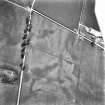
Camp III lies to the north of camp I, and intersects both this camp and camp IV, although the relationship between the three is unknown. Only parts of two sides have been recorded, at least 150m of the WSW side, a rounded southern corner angle and at least 85m of the SSE side. Visible in the interior of the camp is a ring-ditch, which is possibly the remains of a Roman tower.
Camp IV lies to the west of camp III . Only parts of two sides of this camp are known, intersecting camps I and III , and running parallel just inside the NNW side of camp I.
Some 345m of the SSE side has been recorded, together with at least 85m of the WSW side.
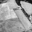
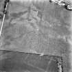
To the south of the group of camps lies camp V, south-east of the fort. Measuring 434m from ENE to WSW by almost 300m, it enclosed 12.9ha (almost 32 acres). Possible entrance gaps are visible in the perimeter but none confirmed. An annexe is attached to its NNW side, measuring some 229m by 78m and enclosing an additional 1.74ha (4.3 acres). This has an internal partition, dividing the internal area to 1.2ha (3 acres) and 0.54ha (1.3 acres) areas. There are a couple of linear cropmarks within the camp but none appears to represent a reduction in the camp, and it is possible that the linear cropmark in the annexe was demarcating different activities in the annexe rather than two phases of use. Alternatively, the cropmark may not be Roman in date, and may represent later use of the annexe enclosure. This camp exhibits a considerable amount of pits in the interior (see section 7f ), and more pits are visible in the area between it and the fort.
R H Jones.
Watching Brief (5 February 2015)
NX 73900 64085 (Canmore ID: 64696) A watching brief was undertaken on 5 February 2015 during the replacement of five electricity poles within the area of the scheduled monument. One machine trench (NX 7406 6407) in the southern perimeter of the southern Roman camp (Camp V) exposed part of a steep-sided pit or ditch but no dating evidence was found. Three other trenches in or close to Camp V produced no archaeological evidence. A shallow, cobble-filled ditch or pit was recorded in a fifth trench E of Marchfield Farm (NX 7396 6490 ); this feature, although similar to some of the foundation trenches investigated in 1951 during the trial excavation of the adjacent fort, is probably part of a post-medieval field drain.
Report: Dumfries and Galloway HER and National Record of the Historic Environment (NRHE)
Funder: CIET (UK) Ltd
John Pickin
(Source: DES, Volume 16)
Note (April 2017)
First contact
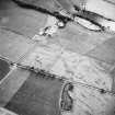
Roman soldiers first entered southern Scotland in the later 1st century AD – tree-ring dating of timbers used to build the fort at Carlisle demonstrates that it was built in about AD 72/3. This would have been accompanied by campaigns in the north prior to the push into southern Scotland which came later in the AD 70s. Soldiers on campaign were housed in temporary camps – these were enclosures with a bank and ditch protecting their perimeter, with soldiers housed in rows of tents in the interior. We have evidence for a number of such temporary camps in south-west Scotland, but their distribution is patchy, showing how many must still remain undetected. A cluster of camps, together with a Roman fort, were recorded from the air in the dry summer of 1949 on the east bank of the River Dee at Glenlochar by Kenneth St Joseph, a pioneer of aerial archaeology based at Cambridge University. The buried remains of ditches reveal themselves as darker markings in the crops growing above, with lighter marks showing the roads within the fort, where crop growth is stunted by the stones below. The site lies at a strategic point right next to the modern bridge (carrying the B 795 road) at one of the few suitable crossing points of the River Dee in this area. At least five camps surround the fort, further emphasing the importance of the location for the Roman army.
Evidence and record
From the air, the familiar ‘playing-card’ shape of the fort can be seen, with multiple ditches around the outside and the gridded pattern of roads within. Lines of dark marks outside the fort to the east reveal the quarry-pits for the Roman road which connected this fort to other Roman bases in the south-west. Small-scale trenches cut across the site in 1952 (this style of excavation was in vogue at the time), showed a 1st century fort (probably dating to the AD 70s) followed by later forts during the Antonine occupation of Scotland in the AD 140s-150s. Whilst other Roman sites are suspected in the area, of note are the number of camps sited around the fort. As some overlap one another and could not have been contemporary, they probably date to multiple Roman incursions in both the phases of campaigning in the 1st century as well as in the 2nd, and probably housed troops “on the march” in south-west Scotland. Marching camps usually reveal more on excavation and geophysical survey than they do from the air, but the southern-most camp displays a higgledy-piggledy array of dark marks in its interior. Evidence from other Roman camps would suggest that these were pits (including, potentially toilet-pits) and also Roman ovens. Some lines can be discerned in the remains, and these may hint at the location of rows of tents (the rubbish pits outside).
The two-week excavation in 1952 suggested that the first fort at Glenlochar was terminated through a ‘wholesale conflagration’. Whether this was as a result of Roman abandonment or enemy action is not possible to determine. Glenlochar still has much to tell us about the Romans in south-west Scotland.
Dr Rebecca Jones - Head of Archaeology and World Heritage

