
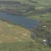
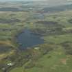
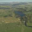
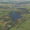
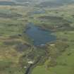
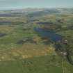
Earlstoun Reservoir, Dam


Dam (Mid 20th Century) (1936)
Site Name Earlstoun Reservoir, Dam
Classification Dam (Mid 20th Century) (1936)
Alternative Name(s) Earlstoun Works; Earlstoun Loch; Earlstoun Dam; Water Of Ken; Galloway Hydro-electric Scheme
Canmore ID 64307
Site Number NX68SW 28.01
NGR NX 61397 82390
NGR Description centred: NX 61376 82308 to NX 61490 82425
Datum OSGB36 - NGR
Permalink http://canmore.org.uk/site/64307


- Council Dumfries And Galloway
- Parish Dalry (Stewartry)
- Former Region Dumfries And Galloway
- Former District Stewartry
- Former County Kirkcudbrightshire
NX68SW 28.01 centred 61397 82390, 61376 82308 to 61490 82425
Location formerly cited as NX 6143 8240.
For associated Earlstoun Power Station (NX 61410 81879), see NX68SW 147.
For adjacent quarry (probably associated with dam construction), see NX68SW 213.
Not to be confused with dam at NX 61312 81959, for which see NX68SW 28.02.
Earlstoun Dam [NAT]
OS 1:10,000 map, 1982.
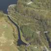
Earlstoun Dam
Purpose: to create head and provide daily storage
Type: arch and gravity
Maximum height of footway above river-bed: 67ft (20.4m)
Total length along crest: 700ft (213.4m)
Length of arch portion of dam: 283ft (86.3m)
Radius of arch portion of dam: 145ft (44.2m)
Batter of downstream face of arch portion of dam: 4.35 to 1
Spillway level: 245ft (74.7m) OD
Normal maximum depth over crest: 3ft (0.9m)
Overfall spillway length: 287ft (87.5m), also two floodgates, each 17ft 6ins (5.3m) by 23ft 6ins (7.2m)
Normal maximum spillway capacity: 20000 cusecs
Anon. 1938 ['Galloway Hydro-Electric Development'].
This dam controls the supply of water to Earlstoun Power Station (NX68SW 147). It forms a major element of stage II of the Galloway Hydro-Electric Scheme
Information from RCAHMS (RJCM), 25 October 2005.
Gibb and Partners et al. 1937.
Project (2007)
This project was undertaken to input site information listed in 'Civil engineering heritage: Scotland - Lowlands and Borders' by R Paxton and J Shipway, 2007.
Publication Account (2007)
Advantage was taken of the existence of a rocky gorge in the bed of the Dee at Earlstoun to construct an arch dam very similar to that at Carsfad. The dam provides a gross head of 69 ft for the Earlstoun Power Station. A concrete gravity section joins to the south end of the arched section of the dam, and this contains the spillway. Two large flood gates assist the discharge of water. The dam was completed in 1937. The consulting engineer
was Alexander Gibb & Partners and the main contractor was A. M. Carmichael Ltd.
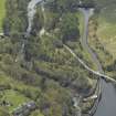
Immediately downstream of the dam is Kirkcudbrightshire County’s Allen Gibbon Bridge built in reinforced
concrete in ca.1926 which is of a type that belies its appearance. The main arch span is flanked by approaches,
the one on the east appearing as arches from its fac¸ades when its spans are in fact straight ‘T’ beams.
R Paxton and J Shipway 2007
Reproduced from 'Civil Engineering heritage: Scotland - Lowlands and Borders' with kind permission from Thomas Telford Publishers.
Field Visit (2010)
This dam controls the flow of water for Earlstoun Powerhouse as well as providing a degree of daily storage. The dam is a combination of concrete gravity and mass concrete and has an integrated spillway. this dam combines gravity and mass concrete sections with a large fixed spillway and is designed on a relatively steep curve to accommodate the shape of the valley. The functionalist classical design which characterises the Galloway scheme is applied to the control tow and the battered downstream face. The landscape presence of the dam is increased by the large gantry to support the paired roller gates to the centre. P L Payne, 1988, 24; E Wood, 2002, 50; G Hill, 1984.

