
Kirkdale Church And Burial-ground


Burial Ground (Medieval), Church (Medieval), Mausoleum (18th Century) (1787)
Site Name Kirkdale Church And Burial-ground
Classification Burial Ground (Medieval), Church (Medieval), Mausoleum (18th Century) (1787)
Alternative Name(s) Kirkdale Kirk And Graveyard; Kirkdale Mausoleum
Canmore ID 63727
Site Number NX55SW 3
NGR NX 51213 54055
NGR Description NX 51213 54055
Datum OSGB36 - NGR
Permalink http://canmore.org.uk/site/63727


- Council Dumfries And Galloway
- Parish Kirkmabreck
- Former Region Dumfries And Galloway
- Former District Wigtown
- Former County Kirkcudbrightshire
NX55SW 3 5121 5405.
(NX 5122 5405) Kirkdale Church (NR) (Remains of)
OS 6" map (1957)
Only fragments remain of Kirkdale Church, which was dedicated to St Michael, situated within an overgrown graveyard. Kirkdale, which belonged to Whithorn Priory, was originally a separate parish, which united with Kirkmabreck in 1618.
H Scott 1917; E M H M'Kerlie 1916
The remains of Kirkdale Church, measuring internally c. 20.0m E-W by 8.5m transversely, and oriented E-W, generally survive as a ruinous wall c.1.0m wide of roughly coursed masonry with pinnings bonded with shell mortar. A fragment of the N wall 5.0m long stands c.3.0m high. Resurveyed at 1:2500.
Visited by OS (RD) 13 March 1972
Photographic Survey (June 1964)
Photographs of Sir Samuel Hannay's mausoleum and the remains of Kirkdale church, Kirkcudbrightshire by the Scottish National Buildings Record in June 1964.
Field Visit (28 April 1994)
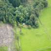
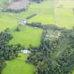
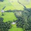
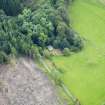
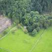
The ruins of this church, and the burial ground which encloses it, stand on a SE-facing slope 450m NNW of Kirkdale Mains farmsteading. The site is overgrown but the burial ground appears to be in occasional use, as there is one gravestone dated 1992.
The church measures 19.9m from E to W by 8.1m transversely within a mortared rubble wall 1.1m thick and up to 2.8m high on the N side, though less well-preserved elsewhere. Within its SE corner there is a later burial enclosure which measures 8.3m by 5.6m within walls 0.7m thick and 2m high. This enclosure has a lintelled doorway in its S side wall. To the W of the church there is a roofed burial vault.
(Cree94 250)
Visited by RCAHMS (SDB) 28 April 1994
Note (20 March 2024)
A ruined church and burial ground is depicted on the 1st edition of the OS 6-inch map (1850).
Information from HES (D Watson) 20 March 2024

