
Wigtown Airfield


Airfield (20th Century)
Site Name Wigtown Airfield
Classification Airfield (20th Century)
Alternative Name(s) Baldoon Airfield; Raf Wigtown
Canmore ID 94519
Site Number NX45SW 41
NGR NX 43308 53612
NGR Description Centred NX 43308 53612
Datum OSGB36 - NGR
Permalink http://canmore.org.uk/site/94519


- Council Dumfries And Galloway
- Parish Kirkinner
- Former Region Dumfries And Galloway
- Former District Wigtown
- Former County Wigtownshire
NX45SW 41.00 centred 43308 53612
NX45SW 41.01 Centred NX 4200 5310 Military Camp
NX45SW 41.02 NX 44572 52527 Tracked Target Range
NX45SW 41.03 NX 43317 53268 Control Tower
NX45SW 41.04 NX 43333 52923 Gas Decontamination centre
NX45SW 41.05 NX 42243 52945 Building (Squash Rackets Court)
NX45SW 41.06 NX 43885 53142, NX 43986 53124 and NX 43947 53037 Bomb Store
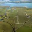
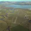
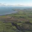
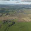
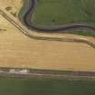
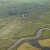
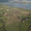
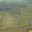
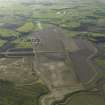
Originally built in connection with target towing on the Burrow Head ranges. At the start of WWII the area was obstructed against enemy landings, but in 1941, the airfield was activated. As there were no hard runways, the landing ground became unusable because of flooding. Two concrete runways were built during 1942, but by 1945 all flying training had ceased and the airfield was transferred to Maintainance Command. The airfield is till used by light aircarft today and many hangar bases can be found around the perimeter. The control tower still stands, but in 1983 it was planned to bulldoze them to provide hardcore for a new harbour project in the nearby town.
D J Smith 1983
The control tower (NX 43316 53268) had still not been demolished when the site was visited in March 2004. Several other buildings were also noted, including a gas decontamination centre (NX 43333 52923) and, to the W of the demolished railway bridge, a squash rackets court still retaining its roof(NX 42243 52945). Also noteworthy are fourteen extant air-raid shelters ranged throughout the site.
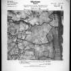
The airfield is visible on postwar RAF vertical air photographs (106G/Scot/UK 42, 4209-4213, flown 4 May 1946). The photographs show that the airfield was equipped with seven large hangars, possibly Bellmans and hard standings for at least 24 Blister hangars, of which twelve were extant on the date of photography. All the buildings and structures in the technical area and the accommodation camp W of Baldoon Hill are clearly shown.
Visited by RCAHMS (DE), March 2004
Note (4 May 2021)
The airfield was protected by at least 19 pillboxes located on the N, W and S sides of the airfield. The pillboxes are either hexagon or 'half a hexagon' in shape, many of which are still extant.
(See NX45SW 100 - 117)
Information from HES (AKK) 4 May 2021

