
Dinnans


Promontory Fort (Period Unassigned), Settlement (Period Unassigned)
Site Name Dinnans
Classification Promontory Fort (Period Unassigned), Settlement (Period Unassigned)
Canmore ID 63252
Site Number NX44SE 2
NGR NX 47920 40570
Datum OSGB36 - NGR
Permalink http://canmore.org.uk/site/63252


- Council Dumfries And Galloway
- Parish Whithorn
- Former Region Dumfries And Galloway
- Former District Wigtown
- Former County Wigtownshire
NX44SE 2 47920 40570
(NX 4792 4057) Promontory Fort (NR)
OS 6" map (1957)
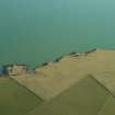
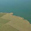
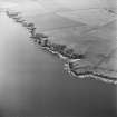
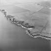
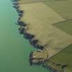
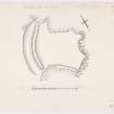
Promontory Fort, Dinnans: The landward, W, side of a small promontory has been defended by a massive earth and rubble rampart 46' at base and 10' high, with an outer ditch 30' broad by 4' deep. One or two boulders are embedded in the outer face of the rampart, suggesting it may have been capped by a wall, though this, if it ever existed, could have been secondary. Probably the original entrance was at the S end, though in 1911 (RCAHMS 1912, visited 1911), entrances are noted at the N and S of the defences. The promontory, under cultivation in 1955, has a grassy slope on its N side, and a rocky tip to the E, both low and easily climbed, though access is more difficult from the S.
RCAHMS TS., visited 1955
Generally as described. The bank and ditch encloses an area measuring 78.0m NW-SE by 65.0m NE-SW. There is no evidence to confirm that a wall existed on top of the bank.
The site is not in a strong defensive position, especially when compared with NX44SE 3, and is therefore best classified as a settlement.
Re-surveyed at 1/2500.
Visited by OS (DWR) 23 January 1973
Field Visit (12 October 1955)
This site was included within the RCAHMS Marginal Land Survey (1950-1962), an unpublished rescue project. Site descriptions, organised by county, are available to view online - see the searchable PDF in 'Digital Items'. These vary from short notes, to lengthy and full descriptions. Contemporary plane-table surveys and inked drawings, where available, can be viewed online in most cases - see 'Digital Images'. The original typecripts, notebooks and drawings can also be viewed in the RCAHMS search room.
Information from RCAHMS (GFG) 19 July 2013.
Note (20 December 2013 - 9 August 2016)
Situated on a coastal promontory, this univallate work cuts off the an area measuring 78m from NW to SE by 65m transversely from the gentle NW approaches. The sides of the promontory are not particularly steep and are easil scaled, but the rampart measures up to 13.8m in thickness by 3m in height and is fronted by a ditch up to 10m in breadth by 1.2m in depth. The entrance is probably on the W, where the S end of the rampart terminates short of the margin of the promontory. The interior, which was under cultivation in the 1950s, is featureless.
Information from An Atlas of Hillforts of Great Britain and Ireland – 09 August 2016. Atlas of Hillforts SC0234
Field Visit (2014)
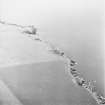
As described. Grass covered, with damage on outer ramparts from cattle. Sea-ward rampart is visibly tumbling down cliff face and is much at risk of further slumping.
Visited by Scotland's Coastal Heritage at Risk (SCHARP) 2014
Field Visit (21 October 2015)
ShoreUPDATE 21/10/2015
Some stock erosion to the rampart, minor slumping above the coast edge. The site sites above and behind high stone cliffs, there is no evidence of coastal erosion.
Visited by Scotland's Coastal Heritage at Risk (SCHARP) 2015

