
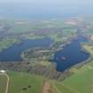
Black Loch, Castle Kennedy


Crannog (Prehistoric), Bracelet (Glass)(Iron Age), Comb (Bone)(Iron Age)
Site Name Black Loch, Castle Kennedy
Classification Crannog (Prehistoric), Bracelet (Glass)(Iron Age), Comb (Bone)(Iron Age)
Alternative Name(s) Stair Estate; Castle Kennedy Policies; Lochinch Castle Policies; Heron Isle
Canmore ID 61754
Site Number NX16SW 7
NGR NX 11396 61183
NGR Description Centre
Datum OSGB36 - NGR
Permalink http://canmore.org.uk/site/61754


- Council Dumfries And Galloway
- Parish Inch
- Former Region Dumfries And Galloway
- Former District Wigtown
- Former County Wigtownshire
NX16SW 7 1139 6118.
(NX 1139 6118) Lake Dwelling (NR) (Site of)
OS 6" map (1957)
Evidence of a crannog was found when the Hon C E Dalrymple excavated the mound in the middle of Heron Isle about 1870-1. The mound was 45' in diameter, rising in the centre to about 3 1/2', with traces of a low wall round the edge.
Some 50' from it, on the weather side of the island, was found a solitary oak pile, suggesting that there had been either a breakwater or a 'chevaux de frise' of sharp pointed stakes.
The wooden floor of the crannog was found to be about 50' in diameter. Traces of several successive occupations were revealed, and the relics included material datable to the 1st and 2nd century AD as well as to later periods, proving that the original structure was of Early Iron-Age date.
RCAHMS 1912; R W Feachem 1963
At the centre of Heron Isle is the large mutilated mound of earth and stones, c.20.0m in diameter and 1.3m maximum height. It is criss-crossed by deep, wide trenches probably dating from the 1870-71 excavations. A slight portion of a low wall, c. 0.3m high, is visible on the east edge of the mound: no traces of piling were seen.
Surveyed at 1/2500.
Visited by OS (WDJ) 29 February 1968
Not visited. The remains of crannog are situated on Heron Isle in the Black Loch, Castle Kennedy. Objects recovered from the crannog include a fragment of glass bangle of the 1st or 2nd century AD, part of the rim of a cast bronze vessel, a bone comb of the early third century AD, and two 17th-century coins.
RCAHMS 1987.
NX 1139 6118 Black Loch, Castle Kennedy; Heron Isle (NX16SW 7). The 'crannog' site reported by Robert Munro in 1882 sits high and dry on the middle of Heron Isle, a large oval island some 45 x 30m. Measuring c 18m in diameter and c 1.5m high, this site was excavated in the 19th century and now survives only as five small stony mounds surrounding a hollow centre. It is uncertain whether this site should be classed as a crannog, since it is unclear whether it was ever surrounded by water. However, Heron Isle itself is composed of stones, on average 30-40cm in diameter, and as such appears to be at least in some part artificial. Timbers were noted within these stones beneath the waterline, though it remains dubious that these are archaeological in nature. Given that the overlying 'crannog' site produced artefacts relating to the 1st-2nd centuries AD, it must therefore remain a possibility that Heron Isle itself was constructed in the prehistoric period.
Two further islands in Black Loch were inspected (at NX 1141 6121 and NX 1120 6132), and although these were found to have been artificially enhanced it is likely that they relate to a major landscaping programme carried out by Lord Stair in the 19th century.
Sponsors: HS, Scottish Trust for Archaeological Research, AOC Archaeology Group, University of Nottingham
M G Cavers and J C Henderson 2002.
Heron Isle, Black Loch, Castle Kennedy (Piltanton catchment): location cited as NX 1139 6118.
The existence of this possible crannog was reported after the excavation of an earth and stone mound in the middle of Heron Isle, in about 1870-1. Objects recovered included a glass bangle of the 1st or 2nd centuries AD, part of the rim of a cast bronze vessel, a bone comb of the early 3rd century AD, and two 17th century coins.
The remains of this crannog were surveyed in July 2002 during the 2nd phase of the South-West Scotland Crannog Survey, with the intention of establishing an effective system of monitoring the rate of organic decay. In the absence of any visible threat, monitoring was not recommended.
The 'crannog' reported by Munro now lies high and dry on the middle of Heron Isle, a large island which is covered by varied woodland, including sycamore and holly. The earth and stone mound measures about 20m in diameter and has been disturbed by excavation, so that it now appears as five mounds of roughly circular shape around a hollowed centre.
This mound is superimposed on an underlying 'island' of boulders; this is oval on plan and measures about 45m by 30m. The margin of the boulders is 10m out from the island, and disappears into silt at a depth of about 3 or 4m. Timbers are present among the boulders in the margins, but none could be identified as structural. No verticals were noted, and the horizontals were loose, suggesting that they may have fallen from the woodland on the island.
It remains to be demonstrated whether the feature excavated in 1871 can be considered a crannog, or whether it was surrounded by water. The larger (underlying) island does appear to be at least partially artificial, and so may be placed within this category. The recovery of dateable artifacts of the 1st or 2nd centuries AD may suggest that the larger (unexcavated) island dates from prehistoric times. Two further islands [locations not cited] in Black Loch were examined, and considered to have been artificially enhanced during an extensive landscaping programme carried out by the Earl of Stair in the 19th century.
J C Henderson, B A Crone and M G Cavers 2003.
Note (1912)
Crannog, Black Loch or Loch Inch Crindil.
About 3 m. to the NE. of Stranraer, and within the policies of Lochinch, lying adjacent to one another, are the White Loch or Loch of Inch, and the Black Loch or Loch Inch Crindil. The latter is over 1 m. in length and of varying width-the widest portion towards the SE. end being some 2/3 m. across. At this end is noted on the O.S. map the site of a crannog on Heron Isle, which gives llame to the place Lochinch. The island was examined by the Hon. C. E. Dalrymple about 1870-71, when the circular mound in the middle of it was excavated and evidence of a crannog obtained. The layers of wood appeared to have covered a space of some 50' in diameter, almost agreeing in size as well as in shape with the mound, which was 45' in diameter, rising in the centre to 3 ½ with traces of a low wall around the edge. Some 50' from it, on the weather side of the island, was found a solitary oak pile, making it probable that there had been a breakwater placed there or a chevaux de frise of sharp-pointed stakes for defence. Fireplaces were found at different levels, and, mixed with ashes and charcoal, were large quantities of bones of animals, mostly more or less burnt. Amongst the relics recovered were a double-margined comb of bone, imperfect, 2 ¾” across, formed of separate pieces enclosed between two transverse slips of bone, fastened with three iron rivets, and ornamented with dots and circles having a running scroll pattern; a flat loop, and the rim of a large vessel of bronze; portion of an armlet of glass with twisted cable ornament; and two copper coins - one a bodle of Charles II. The existence of the copper coins in the crannog is explained by the fact that the island has been planted several times, and considerable quantities of soil and stones added to it. These relics are preserved in the National Museum of Antiquities, Edinburgh.
The White Loch or Loch of Inch, which is smaller than the Black Loch, has also an island upon it, about the middle of its length near the western shore, which, however, appears to be natural. Itis noted on Pont's map as a homestead, and up to the beginning of the 17th century a house of the Earls of Cassillis stood upon it. A small canoe dug out of a single oak tree was found (circa 1870) between the island and the shore [see NX16SW 31] . See Antiquaries, ix. pp. 381 and 388; Scottish Lake Dwellings, p. 57 (comb. illus.); Ayr and Gall. Arch. Coll., v. p. 108 (comb. illus.).
O.S.M., WIGTOWN, xii. SW.
RCAHMS 1912 No. 32
Note (27 November 2021)
The location, classification and period of this site have been reviewed.

