
Craigenholly


Souterrain (Iron Age)(Possible)
Site Name Craigenholly
Classification Souterrain (Iron Age)(Possible)
Canmore ID 82337
Site Number NX15NE 74
NGR NX 18709 58858
NGR Description Centre
Datum OSGB36 - NGR
Permalink http://canmore.org.uk/site/82337


- Council Dumfries And Galloway
- Parish Old Luce
- Former Region Dumfries And Galloway
- Former District Wigtown
- Former County Wigtownshire
Note (6 June 2022)
The location, classification and period of this site have been reviewed and changed from ROUNDHOUSE (PREHISTORIC)(POSSIBLE), SOUTERRAIN (PREHISTORIC)(POSSIBLE).
Aerial Photographic Interpretation (31 March 2022)
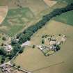
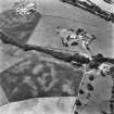
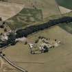
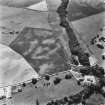
What is likely to be a souterrain has been recorded as parchmarks in grass (RCAHMSAP 1992, 1996) near the edge of a terrace 130m WSW of Craigenholly farmsteading. The souterrain is visible as a gently curving area of lusher grass contrasting with the surrounding parched ground, extending for about 18m in length from NNE to SSW and varying between 2.7m and 3.5m across. Other variegation in the grass across the field appears to be a product of local variations in soil depth rather than archaeological features.
Information from HES Archaeological Survey (D. Cowley) 31 March 2022.

