
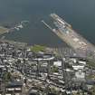
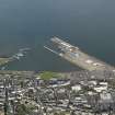
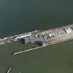
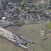
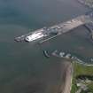
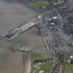
Stranraer Harbour, East Pier


Pier (Period Unassigned)
Site Name Stranraer Harbour, East Pier
Classification Pier (Period Unassigned)
Alternative Name(s) Stranraer Harbour Station; Ross Pier; Railway Pier; Ship Ferry Terminal; Loch Ryan
Canmore ID 297656
Site Number NX06SE 33.01
NGR NX 06129 61439
NGR Description NX 06079 61501 to NX c. 06482 60935
Datum OSGB36 - NGR
Permalink http://canmore.org.uk/site/297656


- Council Dumfries And Galloway
- Parish Stranraer
- Former Region Dumfries And Galloway
- Former District Wigtown
- Former County Wigtownshire
NX06SE 33.01 06129 61439 (NX 06079 61501 to NX c. 06482 60935)
East Pier [NAT] (name centred NX 0609 6150)
OS (GIS) MasterMap, July 2009.
For (integral) Ross Pier (NX 06040 61353 to NX c. 06151 61232, see NX06SE 33.03.
NX06SE 33.01 06129 61439
East Pier on which are located Stranraer Harbour Station (NX06SE 169), and, at the S end, the Ferry Terminal and Ro-Ro Bridge (NX06SE 33.02).
(Undated) information in NMRS.

