
Old Cambus, St Helen's Church


Church (Medieval)
Site Name Old Cambus, St Helen's Church
Classification Church (Medieval)
Alternative Name(s) Old Parish Church; St Helen's Kirk; St Helen's On The Lea; St Helena's Chapel
Canmore ID 59948
Site Number NT87SW 1
NGR NT 80378 70676
Datum OSGB36 - NGR
Permalink http://canmore.org.uk/site/59948


- Council Scottish Borders, The
- Parish Cockburnspath
- Former Region Borders
- Former District Berwickshire
- Former County Berwickshire
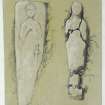
St Helen’s Church 3, Old Cambus, Berwickshire, hogback gravestone
Measurements: L 0.64m, H 0.23m-0.27m, W 0.41m
Stone type: sandstone
Place of discovery: NT 80377067
Present location:
Evidence for discovery: seen in churchyard in 1908. Recorded by Lang in early 1970s outside the south wall of the chancel. Not seen in 2015 but site deep in vegetation.
Present condition: worn and damaged.
Description:
This hogback belongs to Lang’s Illustrative type. It has a flat ridge and a basal vertical plinth. Side A is carved in relief with a quadruped. Side B is carved with four rows of tegulae.
Date: eleventh century.
Desk-based information compiled by A Ritchie 2016
St Helen’s Church 1, Old Cambus, Berwickshire, cross-slab
Measurements:
Stone type: sandstone
Place of discovery: NT 80377067
Present location:
Evidence for discovery: recorded in the nave in 1908. Not seen in 2015, but site deep in vegetation.
Present condition:
Description:
Incised on one broad face of an undressed slab is a cross-of-arcs with traces of a square frame.
Date: eighth or ninth century.
Desk-base information compiled by A Ritchie 2016
St Helen’s Church 2, Old Cambus, Berwickshire, hogback gravestone
Measurements: L 1.50m, H 0.28m, W 0.32m-0.37m
Stone type: sandstone
Place of discovery: NT 80377067
Present location:
Evidence for discovery: seen in churchyard in 1908. Recorded by Lang in early 1970s in churchyard near east gable of church. Not seen in 2015 but site deep in vegetation.
Present condition: very worn and the west end is damaged.
Description:
This hogback belongs to Lang’s Illustrative type. It has a flat ridge and a basal vertical plinth. Side A is divided into three panels, each carved in relief with a quadruped, two separated by a stylised tree. Side B is carved with three rows of tegulae.
Date: eleventh century.
Desk-based information compiled by A Ritchie 2016
NT87SW 1.00 80378 70676
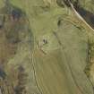
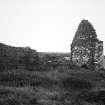
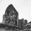
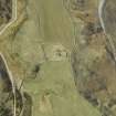
(NT 80378 70676) St Helen's Church (NR) (remains of)
OS 1:10,000 map, (1976).
NT87SW 1.01 80368 70654 Churchyard (Hogback Stones)
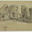
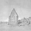
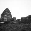
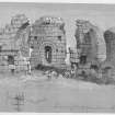
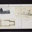
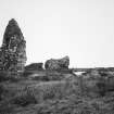
The surviving remains of this 12th century church show that it was extensively rebuilt in the late 14th or 15th century. It consisted of a nave and chancel as shown on D MacGibbon and T Ross plan (qv), both were originally roofed with a barrel-vault, of which only a few indications now remain. The E and S walls of the chancel have been almost completely removed, but the N wall still stands 8 to 10ft high. Parts of the N
and S walls of the nave remain to a considerable height. At the W end of the N and S walls there is a rough opening which may indicate the position of two entrance doorways. The upper part of the N wall is said to have been rebuilt; the W gable was also rebuilt, and is in a better state of repair, consisting of a plain wall with a buttress at each angle.
This church, which was dedicated to St Helen, was the church of the former parish of Aldcambus and probably fell into ruin when that parish was united with the parish of Cockburnspath before 1750.
RCAHMS 1915, visited 1908; D MacGibbon and T Ross 1896; A Reid 1914; T S Muir 1862; RCAHMS 1980, visited 1979; A A Carr 1836; I B Cowan 1967.
The fragmentary remains now comprise the W wall, which is almost intact, and portions of the N and S walls.
Visited by OS (JLD) 28 October 1954.
No change.
Revised at 1/2500.
Visited by OS (NKB) 21 December 1965.
St Helens Church. The original 12th century church was extensively rebuilt in the late 14th or 15th century. It probably went into disuse when the parish of Aldcambus was united with Cockburnspath before 1750. The remains were described in 1954 as being fragmentary, comprising the W wall and portions of the N and S walls. The church is as described. The church is in an exposed location but well away from the sea and so is not affected immediately by coastal erosion.
Site recorded by GUARD during the Coastal Assessment Survey for Historic Scotland, 'The Firth of Forth from Dunbar to the Coast of Fife' 25th February 1996.
NMRS REFERENCE:
NMRS - J. Drummond SAS 386 p.25 & 116
Field Visit (4 November 1908)
46. St Helen's Church.
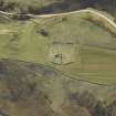
The ruins of this church are situated on a lofty headland overlooking the sea-coast about 2 miles east of Cockburnspath and ¼ mile north of Old Cambus, West Mains. The church has been of the simple Norman type, consisting of a small rectangular chancel measuring 15 feet 2 inches by 11 feet 6 inches and a nave 30 feet 9 inches by 18 feet, within walls averaging 3 feet in thickness. The west gable is obviously of later date. Both nave and chancel have been originally roofed with a barrel-vault of which only a few indications remain at the level of the springing. The east and south walls of the chancel are now almost razed to the ground, but the north wall, which has been formed without openings, remains to a height of about 8 or 10 feet above the ground level. According to the description of this church by Mr T. S. Muir in 1845, there was originally a narrow east light having a slightly pointed arch-head to the exterior, while the arch-head to the interior was semicircular in form, set in a recess, and decorated on the arch and jambs with a single chevron. According to the same authority, the chancel arch has been about 7 feet in width. It is now represented by broken and fragmentary jambs which have probably consisted of a central engaged shaft flanked by two smaller shafts of the same type. The caps and bases are now demolished, but the continuation of the north abaci can still be made out on the north-east face of the nave wall, decorated with a series of incised rosettes. The west wall-face on each side of the chancel arch has contained a rectangular recess. Similarly placed arched recesses occur one on each side of the chancel arch at Tyninghame in East Lothian [NT67NW 13]. Their purpose, however, seems to be uncertain. Portions of the north and south walls of the nave remain to a considerable height. At the west end of the north and south walls there is a rough opening which may indicate the position of two entrance doorways. The upperpart of the north wall is said to have been rebuilt. In the south wall there were two windows having. three wall recesses with segmental arch-heads formed below the level of the sills, each measuring from 4 to 5 feet in width, 11 inches in depth, and 3 feet above the present ground level. Unfortunately a small. portion at the east end of this wall is all that now survives. The west gable has been rebuilt in the later style of the 14th or 15th century, and is consequently in a better state of repair. It consists of a plain wall with a diagonal buttress of three stages at each angle. The wall has seven rows of square put-log holes, all of which, except the lowest row, pierced the wall. These were perhaps intended to hold the ends of timber scaffolding. Similar holes are found in what remains of the other walls.
Aldcambus was formerly a separate parish, but is now merged in Cockburnspath, and its church was dedicated to St Helen. The Manor of Aldcambus was granted by King Edgar to the Monks of Durham in 1100, and it ‘belonged to the monastery of Coldingham as a cell of Durham’, but obviously the church is of later date. The ornamental design wrought on the abaci, which is the only detail that survives, is similar in character to that which occurs on the abaci of the chancel arch of Legerwood Church (No. 239).
See Eccles. Arch., i. p. 323 (plan and illus. ); Ber. Nat. Club, 1890-91, p. 102; Antiquities, iii. p. 296 (plan and illus.); Carr's Coldingham, p. 98 (illus.); Lawrie's Early Scottish Charters, p. 17.
RCAHMS 1915, visited 4 November 1908
OS Map: Ber., i. SE.
Excavation (10 March 2021 - 11 March 2021)
NT 80378 70676 A survey and limited excavations were undertaken at St Helen’s Church, (Canmore ID: 59948), following reports of unauthorised excavations there. The work took place 10–11 March 2021.
Two hogback stones were located and excavated (Early Medieval Carved Stones Project’s St Helen’s Church 2 and 3) so that their condition could be assessed. The stones were found to be in good condition. They were comprehensively recorded, covered back over and the turf reinstated.
A recumbent grave slab incised with the figure of a knight or warrior was also identified, previously noted by Reid (PSAS 48, 220).
No other finds were made during the excavations.
The aforementioned stones, and the site of St Helen’s Church and its churchyard, were surveyed. Thirty-four visible burial monuments were assigned a number and photographed. Laser scanning was undertaken using a Trimble TX5 3D laser scanner. Reference spheres placed at various points around the survey area were used to tie the laser scanner survey together. A measured plan of the site and the reference spheres were surveyed using a Trimble S6 total station tied into the National Grid using a Trimble R6 dGPS. The whole site was also recorded in high detail using structure-from-motion photogrammetry. Source images for the 3D outputs were captured with a full frame mirrorless camera (24Mpx). Supplementary TLS data was collected for archival purposes and georeferencing.
Archive: NRHE
Funder: Historic Environment Scotland
Charlotte Douglas – AOC Archaeology Group
(Source: DES Vol 22)
Sbc Note
Visibility: Upstanding building, which may not be intact.
Information from Scottish Borders Council

