
Westerside


Settlement (Prehistoric)
Site Name Westerside
Classification Settlement (Prehistoric)
Canmore ID 59801
Site Number NT86NE 9
NGR NT 8913 6866
Datum OSGB36 - NGR
Permalink http://canmore.org.uk/site/59801


- Council Scottish Borders, The
- Parish Coldingham
- Former Region Borders
- Former District Berwickshire
- Former County Berwickshire
NT86NE 9 8913 6866.
(NT 8913 6866) Settlement (NR)
OS 1:10,000 map, (1976).
A small oblong enclosure surrounded by a single low mound. The W half of the enclosure contains a number of irregular depressions, defined by low banks, into one of which the entrance (6ft wide, in the middle of the W side) opens.
RCAHMS 1915, visited 1908.
There seem to be three separate enclosures on top of the elongated bluff, the middle one of which contains hut circles. There is faint evidence that the whole bluff may have been enclosed by a wall.
Information from Sir W de L Aitchison, 1951.
This earthwork comprises a low, spread bank, the E part of which is almost obliterated. Elsewhere it reaches a height of only 0.3m. The interior is considerably broken, but faint traces of three large depressed areas can be seen. The enclosure is situated on a low, elevated portion of ground and is of a non-defensive character.
Visited by OS (JLD) 4 November 1954.
This settlement is generally as described in the previous field report. Its E and S sides have been almost obliterated by cultivation and the W side exists as a scarp only, some 1.5m high.
Resurveyed at 1:2500.
Visited by OS (WDJ) 1 March 1966.
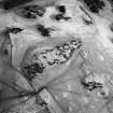
This settlement occupies a low knoll about 420m ESE of Waterside farmhouse. Subrectangular on plan, it measures 36m by 22m within a bank up to 3.6m thick and 0.4m high. In the centre of the interior there is a possible house site; other depressions may be either natural features or the result of quarrying.
RCAHMS 1980, visited 1979.
Field Visit (18 August 1908)
81. Fort, Coldingham Loch.
About 500 feet south of the northwest end of Coldingham Loch, on a slight rocky elevation some 50 feet above the level of the loch, there is a small enclosure (fig. 43), oblong in form, with a diameter from north to south of 132 feet, and from east to west of 89 feet, surrounded only by a single low mound. The entrance, near the middle of the west side, is some 6 feet wide. The west half of the enclosure contains a number of irregular depressions, defined by low banks, into one of which the entrance opens.
RCAHMS 1915, visited 18th August 1908.
OS Map: Ber., v. NE. and vi. NW.
Field Visit (5 August 1950)
Settlements, Coldingham Loch, (Inventory Nos. 81, 85, 86 and 87).
All these structures are Romano-British or Dark Age settlements, comparable to those in Roxburghshire.
Visited by RCAHMS (KS) 5 August 1950.
Sbc Note
Visibility: This is an upstanding earthwork or monument.
Information from Scottish Borders Council

