
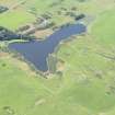
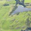
Coldingham Loch


Fort (Prehistoric), Settlement (Prehistoric)
Site Name Coldingham Loch
Classification Fort (Prehistoric), Settlement (Prehistoric)
Alternative Name(s) Biter's Craig
Canmore ID 59770
Site Number NT86NE 12
NGR NT 8988 6868
Datum OSGB36 - NGR
Permalink http://canmore.org.uk/site/59770


- Council Scottish Borders, The
- Parish Coldingham
- Former Region Borders
- Former District Berwickshire
- Former County Berwickshire
NT86NE 12 8988 6868
(NT 8988 6868) Fort and Settlement (NR)
OS 1:10,000 map, (1976).
For nearby discovery of long cist, see NT86NE 16.
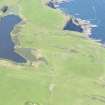
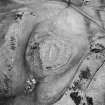
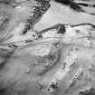
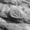
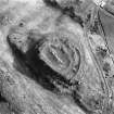
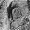
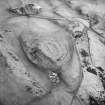
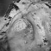
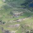
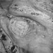
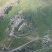
This fort occupies a rocky knoll (160m OD) overlooking Coldingham Loch. D-shaped on plan (qv), it measures about 49m by 36m internally and is defended by a wall and two ramparts on all sides except the NNW, where there is a steep slope. The defences have been mutilated by the insertion of at least six stone-walled houses, a house platform, and a number of scoops which may be small quarries. This is an example of the open settlements which grew up at disused forts in the second and succeeding centuries AD (R W Feachem 1963).
RCAHMS 1915, visited 1908; RCAHMS 1980, visited 1979.
When seen in 1966, this fort and settlement were in a similar condition to that described above.
Surveyed at 1:2500.
Visited by OS (RD) 11 March 1966.
Scheduled as 'Coldingham Loch, fort and settlement 530m S of Biter's Craig...'
Information from Historic Scotland, scheduling document dated 5 March 2009.
Field Visit (18 August 1908)
84. Fort, Coldingham Loch.
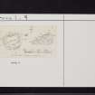
Some 400 feet north-north-east of the east end of Coldingham Loch is an enclosure (fig. 46 [BWD 13/1]) occupying the summit of a rocky knoll, very steep and rugged on the north side. It is sub-oval inform, with a single rampart along the edge of the rocks on the north, and a triple rampart, with a ditch between the middle and outer ramparts, on the remainder of the periphery. The entrance is from the south-east, and passes between a number of circular foundations the internal diameter of which varies from 16 to 18 feet. The secondary character of some of these foundations is indicated by the fact that they are actually placed upon the line of the ramparts as well as between them, the two outer ramparts on the east being much interrupted thereby. Two or three circular foundations are also visible in the interior. At the south-west the bottom of the ditch is 9 feet below the crest of the middle rampart and 3 feet below that of the outer one, while the inner rampart is only about 2 feet high. From crest to crest the defences at the south-west measure 56 feet across. The dimensions of the interior are 170 by 125 feet. The ramparts are of earth and stone.
See Antiquities, xxix. p. 173 (plan).
RCAHMS 1915, visited 18th August 1908.
OS Map: Ber., v. NE. and vi. NW.
Field Visit (5 August 1950)
This site was included within the RCAHMS Marginal Land Survey (1950-1962), an unpublished rescue project. Site descriptions, organised by county, are available to view online - see the searchable PDF in 'Digital Items'. These vary from short notes, to lengthy and full descriptions. Contemporary plane-table surveys and inked drawings, where available, can be viewed online in most cases - see 'Digital Images'. The original typecripts, notebooks and drawings can also be viewed in the RCAHMS search room.
Information from RCAHMS (GFG) 19 July 2013.
Note (11 February 2016 - 30 May 2016)
This fort is situated on a rocky hillock overlooking the E tip of Coldingham Loch. The defences comprise two elements, namely an inner wall, which forms a complete circuit, and an outer pair of ramparts with a medial ditch backing onto the rugged NW flank of the hillock, and though the sequence cannot be demonstrated stratigraphically, it is likely that the inner enclosure has been inserted into an earlier fort. The inner rampart of the latter follows the shoulder of the hillock, forming a scarp that falls away up to 2.5m into the bottom of the ditch, and encloses a D-shaped area measuring 65m from ENE to WSW parallel to the chord on the NW by about 50m transversely (0.28ha). On the W, where the counterscarp rampart is also best preserved, the NW end of the ditch has not been cut through the rock outcrops, but the entrance was more probably on the SE. Here the ramparts appear to return and unite around the terminals of the ditch, though this feature is possibly the result of later demolition to create access into the later settlement overlying the ramparts and there is another possible gap on the S. The wall of the inner enclosure, reduced to a bank of rubble between 3.1m and 6.5 m in thickness and up to 0.7m in height, encloses an area measuring 49m from ENE to WSW by 36m transversely (0.15ha),and it too was probably entered from the SE, though this side has been mutilated by an overlying settlement of stone-founded round-houses. Although no stratigraphic sequence can be observed between the inner enclosure and the ramparts of the fort, the inner wall is not only set well back from the shoulder of the hillock, but the space between it and the inner rampart of the outer defences varies from about 6m on the SW to 12m on the SE, features that strongly suggest they were not conceived as a single scheme. The later settlement comprises at least six stone-founded round-houses, the largest some 6.9m in diameter, which have mainly been inserted into the space between the inner enclosure and the outer ramparts and evidently overly both; a platform and four other scoops dug into the rubble of the ramparts on the SE are possibly other structures but may be no more than small quarry pits.
Information from An Atlas of Hillforts of Great Britain and Ireland – 30 May 2016. Atlas of Hillforts SC4096
Sbc Note
Visibility: This is an upstanding earthwork or monument.
Information from Scottish Borders Council

