
Chirnsidebridge, Railway Bridge


Railway Bridge (19th Century)
Site Name Chirnsidebridge, Railway Bridge
Classification Railway Bridge (19th Century)
Alternative Name(s) Chirnsidebridge Paper Mill, Former Railway Bridge; Chirnside Railway Bridge; Whiteadder Water
Canmore ID 230915
Site Number NT85NE 86
NGR NT 85026 56391
Datum OSGB36 - NGR
Permalink http://canmore.org.uk/site/230915


- Council Scottish Borders, The
- Parish Chirnside
- Former Region Borders
- Former District Berwickshire
- Former County Berwickshire
NT85NE 86 85026 56391
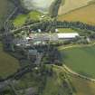
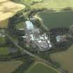
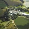
This bridge formerly carried the Reston-St Boswells branch line of the North British Rly over the Whiteadder Water immediately North of Chirnside Paper Mill (NT85NE 69). The river here defines the boundary between the parishes of Chirnside (to the N) and Edrom (to the S).
The line opened in 1863, and closed to passengers in September 1951 and to freight in 1965.
Information from RCAHMS (RJCM), 1 April 2009.

