
Ladykirk, Lower Toll Cottage


Toll House (Post Medieval)
Site Name Ladykirk, Lower Toll Cottage
Classification Toll House (Post Medieval)
Alternative Name(s) Norham Bridge Cottage; Ladykirk And Norham Bridge, Tollhouse
Canmore ID 88186
Site Number NT84NE 52
NGR NT 88959 47303
Datum OSGB36 - NGR
Permalink http://canmore.org.uk/site/88186


- Council Scottish Borders, The
- Parish Ladykirk
- Former Region Borders
- Former District Berwickshire
- Former County Berwickshire
NT84NE 52 88959 47303
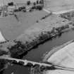
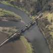
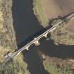
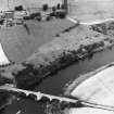
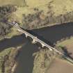
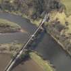
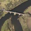
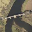
For Ladykirk and Norham Bridge (adjacent to E), see NT84NE 50.
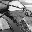
The lower toll cottage at Ladykirk and Norham Bridge (NT84NE 50) is visible on large scale air photographs (OS 71/050/032, flown 1971).
(Undated) information in NMRS.
(Location cited as NT 890 473). Ladykirk-Norham Bridge, and tollhouse, built 1885-7. The tollhouse is a single-storey three-bay structure, with a central stone porch.
J R Hume 1976.
Sbc Note
Visibility: This is an upstanding building.
Information from Scottish Borders Council.

