
Caldra House, Walled Garden


Walled Garden (Period Unassigned)
Site Name Caldra House, Walled Garden
Classification Walled Garden (Period Unassigned)
Canmore ID 74367
Site Number NT74NE 11.01
NGR NT 77171 49307
NGR Description Centred NT 77171 49307
Datum OSGB36 - NGR
Permalink http://canmore.org.uk/site/74367

- Council Scottish Borders, The
- Parish Fogo
- Former Region Borders
- Former District Berwickshire
- Former County Berwickshire
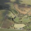
The walled garden belonging to Caldra House is situated on sloping ground to the south-west of the house. It probably dates from the first half of the nineteenth century, and the 1st edition of the Ordnance Survey 6-inch map, published in the mid-nineteenth century, illustrates the formal layout of paths that existed within at this time.
A rubble-built bothy stands next to the north-west wall of the garden. It is a single-storeyed structure, with an attic floor lit by gabled windows, which, together with the with the timber canopy above the door, were included to give the structure a picturesque appearance.
A conservatory once also stood against the north-west garden wall, but this has been removed in recent years.
Text prepared by RCAHMS as part of the Accessing Scotland's Past project
NT74NE 11.01 77171 49307
Visible on Ordnance Survey large scale vertical air photograph (#S 70/365/207).
Sbc Note
Visibility: This is an upstanding earthwork or monument.
Information from Scottish Borders Council

