
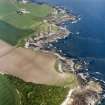
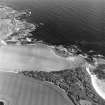
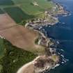
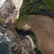
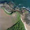
'Auldhame', Seacliff


Lairds House (16th Century)
Site Name 'Auldhame', Seacliff
Classification Lairds House (16th Century)
Alternative Name(s) St. Baldred's House; Seacliffe
Canmore ID 57846
Site Number NT68SW 1
NGR NT 6023 8462
Datum OSGB36 - NGR
Permalink http://canmore.org.uk/site/57846


- Council East Lothian
- Parish Whitekirk And Tyninghame
- Former Region Lothian
- Former District East Lothian
- Former County East Lothian
NT68SW 1 6023 8462
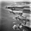
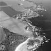
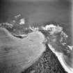
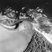
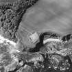
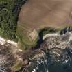
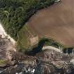
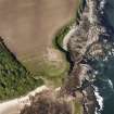
(NT 6023 8462) Auldhame (NR) (remains of)
OS 6" map (1969)
St Baldred's House (NR) (In Ruins)
OS 6" map (1908)
For Seacliff House (NT 6081 8431) and associated buildings, see NT68SW 28.
Not to be confused with NT68SW 30.
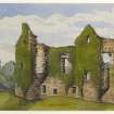
Auldhame was originally published as St Baldred's House as it was traditionally said to have been the residence of that saint, though other local informants thought that it may have been the remains of a church (see NT68SW 17). However, it is now recognised as a 16th century laird's house (J S Richardson, 7a Tantallon Terrace, N Berwick, 16 December 1952).
The remains, when seen in 1913, consisted of a main block measuring 59ft 9 ins NNW-SSE by 27ft 4 ins transversely; from the E wall two rectangular towers projected to the E and there were circular turrets corbelled out in the northern re-entrant angles. There appeared to have been circular turrets at the N angles of the main block, and outbuildings against the W wall. The building had stood at least three storeys high. The basement, or part of it, has been vaulted and on the first floor was a fragment of a 17th century plaster frieze. The structure was in very bad condition.
Name Book 1853; RCAHMS 1924, visited 1913
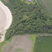
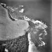
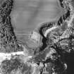
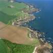
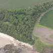
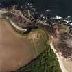
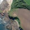
The remains of this 16th century house, still in a very poor condition, are generally as described by the RCAHMS. The remains of a wall running WSW from the SW angle of the main block can be seen in two portions of walling still standing to a height of about 3m. The piece of wall nearer the main block contains a rectangular gateway or doorway with moulded jambs; the second piece is located 38m SSE of the SE angle. Also, traces of walling can be seen along the cliff edge between the latter piece of walling and the SE angle of the main block. From this last portion of isolated wall a low stony bank curves W for a distance of some 30m to merge with a modern stone wall. This bank is 2.2m wide and there is evidence of a shallow ditch, 2.5m wide, on its N side. The bank is 0.7m high above the ditch bottom but only 0.1m above the outside ground level.
Visited by OS (WDJ) 13 November 1962
Scheduled as laird's house.
Information from Historic Scotland, scheduling document dated 17 February 1993.
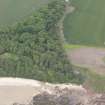
Traditionally known as St Baldred's House, identified by 1952 as a lairds house. The remains are in a poor condition. It stands right on the edge of a slope which has little vegetation cover to stabilise it and is therefore vulnerable to erosion.
Site recorded by GUARD during the Coastal Assessment Survey for Historic Scotland, 'The Firth of Forth from Dunbar to the Coast of Fife' 26th February 1996.
Field Visit (1853)
Recorded in the Ordnance Survey Object Name Book.
Name Book 1853.
Field Visit (27 August 1913)
202. Auldhame.
Auldhame stands on one of the sea cliffs from which the estate of Seacliff is named about a mile south-west of Tantallon Castle. The site is very beautiful, overlooking a little crescentic bay bordering the estuary of the Forth between the Gegan and Car Rocks. The ruin, which is that of a large 16th century mansion, consists of a main block measuring 59 ¾ feet from north-north-west to south-south-east by 27 feet 4 inches from east-north-east to west-south-west; from the eastern wall two rectangular towers project eastwardly and circled turrets are corbelled out in the northern re-entering angles. At the northern angles of the main block there appear to have been circled turrets, and against the western wall were outbuildings. The building has been at least three storeys in height; the basement, or a portion of it, has been vaulted. On the first floor there is a fragment of a17th century plaster frieze. The structure is in very bad condition.
HISTORICAL NOTE.
Auldhame belonged to the family of Otterburn; Sir Adam Otterburn of Reidhall and Auldhame, son of a merchant burgess of Edinburgh, was King's Advocate in the reign of James V (1). In 1594 there was a charter of novodamus by James VI to Thomas Otterburn of Reidhall and Mariota Lauder his wife of the lands of Auldhame, etc. in the barony of Tynningham, the regality of St. Andrews, etc (2).
RCAHMS 1924, visited 27 August 1913.
(1) Omond's Lord Advocates i., p. II; (2) Reg.Mag. Sig. s.a., No. 86.
OS Map ref: iii. S.W. (‘St. Baldred's House’)
Field Visit (13 November 1962)
The remains of this 16th century house, still in a very poor condition, are generally as described by the RCAHMS. The remains of a wall running WSW from the SW angle of the main block can be seen in two portions of walling still standing to a height of about 3m. The piece of wall nearer the main block contains a rectangular gateway or doorway with moulded jambs; the second piece is located 38m SSE of the SE angle. Also, traces of walling can be seen along the cliff edge between the latter piece of walling and the SE angle of the main block. From this last portion of isolated wall a low stony bank curves W for a distance of some 30m to merge with a modern stone wall. This bank is 2.2m wide and there is evidence of a shallow ditch, 2.5m wide, on its N side. The bank is 0.7m high above the ditch bottom but only 0.1m above the outside ground level.
Visited by OS (WDJ) 13 November 1962
Field Visit (26 February 1996)
Traditionally known as St Baldred's House, identified by 1952 as a lairds house. The remains are in a poor condition. It stands right on the edge of a slope which has little vegetation cover to stabilise it and is therefore vulnerable to erosion.
Site recorded by GUARD during the Coastal Assessment Survey for Historic Scotland, 'The Firth of Forth from Dunbar to the Coast of Fife' 26th February 1996.

