
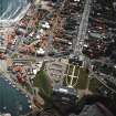
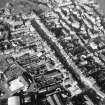
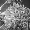
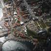
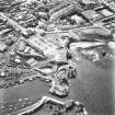
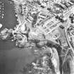
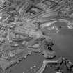
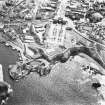
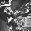
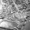
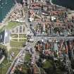
Dunbar, Castle Park


Building(S) (Early Medieval), Courtyard (12th Century), Cross (7th Century), Promontory Fort (Iron Age), Wall(S) (Medieval), Coin(S) (Early Medieval)
Site Name Dunbar, Castle Park
Classification Building(S) (Early Medieval), Courtyard (12th Century), Cross (7th Century), Promontory Fort (Iron Age), Wall(S) (Medieval), Coin(S) (Early Medieval)
Alternative Name(s) Leisure Pool Development; Dunbar Castle Park; Db87; Db88f; Db03a; Db08
Canmore ID 68375
Site Number NT67NE 141
NGR NT 67803 79214
NGR Description NGR centred on 67803 79214
Datum OSGB36 - NGR
Permalink http://canmore.org.uk/site/68375


- Council East Lothian
- Parish Dunbar
- Former Region Lothian
- Former District East Lothian
- Former County East Lothian
NT67NE 141.00 centred on 6779 7922
See also NT67NE 473 and NT67NE 501
NT67NE 141.01 6776 7917 Trial Excavation; fort
NT67NE 141.02 6788 7920 Watching briefs; culvert, possible; burials
NT67NE 141.03 6783 7925 Ice House
NT67NE 141.04 6783 7912 Watching brief; burial-ground; cists:long
NT67NE 141.05 6779 7910 Burials
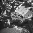
Excavation on this site took place between March-August 1988 in advance of a leisure complex development by East Lothian District Council. The edge of the defensive ditch of the French fortification of 1550 was located, surrounding a sizeable broken stone courtyard. An earlier courtyard possibly of 12th or 13th century date was revealed below the French fort. This courtyard overlay a 2.5m wide sandstone wall running on a NW-SE alignment along the cliff top. An external path or yard was found on the W side of this wall. This wall possibly represents a W curtain wall around Dunbar Castle which lies some 85m E of the excavation.
The levels below the wall overlay the demolished remains of two stone and one timber building. The most completely recovered building was a rectangular structure with an internal paved walkway and the suggestion of a curved S end-wall. Finds from levels associated with these structures include two Northumbrian styca coins and an Anglo-Saxon sceatta. Other finds include decorated spondle whorls, whetstones and a decorated bone pin beater. There is the suggestion that these finds are all residual and do not indicate a date for the stone buildings.
The buildings had been erected on a large area of cobbling that formed a yard surface at the E end of the excavation trench. Below this yard the ground plans of two timber structures were located. The later of the two structures was represented by 3 linear beam slots, one of which contained a gilded bronze book clasp, as yet undated.
Further excavation took place on this site between October 1988 and March 1989. The W ends of two timber halls of possibly Anglian date were revealed. These halls overlay an earlier stone surface which sealed two substantial ditches running across the headland. C14 dates of 116 AD-449 AD were obtained from charcoal samples taken from the stone surface.
Excavations at Castle Park, Dunbar continued under the direction of Philip Holdsworth. An extensive gravel surface sealed the remains of a medieval stone rampart which had never been completed. Evidence of two more timber structures was uncovered, one of individual post-hole construction, the other of trench and post construction; both may date to the Anglian period.
D Hall and P Holdsworth 1989.
A fourth phase of excavation on the headland took place during November and December 1991. Four main phases of activity were identified.
Phase 1: The earliest activity on the site consisted of a N/S ditch which formed part of the Native British promontory fort identified in the earlier excavation. This was followed by Dark Age activity.
Phase 2: Dark Age activity consisted of a possible large sunken floored building surrounded by two concentric post-trenches. Unfired clay loomweights were recovered from the floor of this feature.
Phase 3: Medieval occupation on the site was associated with Dunbar Castle. the foundations for the curtain wall were excavated as was an associated cobbled surface.
Phase 4: In the early post-medieval period part of the curtain wall was robbed out, presumably to be used in the contruction of the 16th century French fort.
Sponsors: HS, East Lothian Community Development Trust
C J Moloney 1992
This site falls within the area scheduled as Dunbar Castle Park.
Information from Historic Scotland, scheduling document dated 20 April 1994.
Site excavated between March 1988 and March 1989 (SUAT). The earliest structures on site were the remains of two Anglo-Saxon type timber halls, and other associated features. A 12th or 13th century courtyard overlay an earlier wall. One of the latest features on site was the edge of a defensive ditch of 1550, overlain by a mid 17th century stone building. Holdsworth P Hall D, 1996, Molony C, 1992 Sermon R S, 1991
Site recorded by GUARD during the Coastal Assessment Survey for Historic Scotland, 'The Firth of Forth from Dunbar to the Coast of Fife' 1996.
Excavation (1988 - 1989)
Excavation on this site took place between March-August 1988 in advance of a leisure complex development by East Lothian District Council. The edge of the defensive ditch of the French fortification of 1550 was located, surrounding a sizeable broken stone courtyard. An earlier courtyard possibly of 12th or 13th century date was revealed below the French fort. This courtyard overlay a 2.5m wide sandstone wall running on a NW-SE alignment along the cliff top. An external path or yard was found on the W side of this wall. This wall possibly represents a W curtain wall around Dunbar Castle which lies some 85m E of the excavation.
The levels below the wall overlay the demolished remains of two stone and one timber building. The most completely recovered building was a rectangular structure with an internal paved walkway and the suggestion of a curved S end-wall. Finds from levels associated with these structures include two Northumbrian styca coins and an Anglo-Saxon sceatta. Other finds include decorated spondle whorls, whetstones and a decorated bone pin beater. There is the suggestion that these finds are all residual and do not indicate a date for the stone buildings.
The buildings had been erected on a large area of cobbling that formed a yard surface at the E end of the excavation trench. Below this yard the ground plans of two timber structures were located. The later of the two structures was represented by 3 linear beam slots, one of which contained a gilded bronze book clasp, as yet undated.
Further excavation took place on this site between October 1988 and March 1989. The W ends of two timber halls of possibly Anglian date were revealed. These halls overlay an earlier stone surface which sealed two substantial ditches running across the headland. C14 dates of 116 AD-449 AD were obtained from charcoal samples taken from the stone surface.
Excavations at Castle Park, Dunbar continued under the direction of Philip Holdsworth. An extensive gravel surface sealed the remains of a medieval stone rampart which had never been completed. Evidence of two more timber structures was uncovered, one of individual post-hole construction, the other of trench and post construction; both may date to the Anglian period.
D Hall and P Holdsworth 1989.
Excavation (November 1991 - December 1991)
A fourth phase of excavation on the headland took place during November and December 1991. Four main phases of activity were identified.
Phase 1: The earliest activity on the site consisted of a N/S ditch which formed part of the Native British promontory fort identified in the earlier excavation. This was followed by Dark Age activity.
Phase 2: Dark Age activity consisted of a possible large sunken floored building surrounded by two concentric post-trenches. Unfired clay loomweights were recovered from the floor of this feature.
Phase 3: Medieval occupation on the site was associated with Dunbar Castle. the foundations for the curtain wall were excavated as was an associated cobbled surface.
Phase 4: In the early post-medieval period part of the curtain wall was robbed out, presumably to be used in the contruction of the 16th century French fort.
Sponsors: HS, East Lothian Community Development Trust
C J Moloney 1992
Archaeological Evaluation (July 2009 - July 2009)
NT 678 792 An evaluation for an amenity block was carried out at Dunbar Harbour in July 2009 on a site formerly occupied by a military gymnasium and ballroom. The proposed development area lies in the scheduled area associated with Dunbar Castle.
Trial trenching led to the identification of two lengths of wall. The walls were both of red sandstone and grey granite construction and ran at 90º to one another, suggesting that they may have been part of the same building. The walls were sealed by a deposit containing red sandstone fragments, shell, carbon flecks and fragments of bone. The date of the walls was not established but their nature suggests that they pre-date the military gymnasium and ballroom. It is possible that the walls relate to structures depicted on Roy’s Military map (c 1750), but the scale and quality of the mapping does not allow their exact position to be pinpointed.
Archive: East Lothian Council SMR and RCAHMS
Funder: Dunbar Harbour Trust
Magnus Kirby - CFA Archaeology Ltd

