
Crow Stones


Stone Circle (Prehistoric)
Site Name Crow Stones
Classification Stone Circle (Prehistoric)
Canmore ID 57491
Site Number NT66NW 20
NGR NT 61843 65195
NGR Description Centre
Datum OSGB36 - NGR
Permalink http://canmore.org.uk/site/57491


- Council East Lothian
- Parish Whittingehame
- Former Region Lothian
- Former District East Lothian
- Former County East Lothian
NT66NW 20 6183 6519.
(NT 6181 6519) Crow Stones (NAT)
OS 6" map (1957)
The 'Crow Stones' are a large circle of stones, on a hearthy eminence at the S end of Crow Moss. They are supposed by some to have been a 'Druidical Circle', but no satisfactory account of them can be obtained locally. Everyone agrees, however, that they are ancient, and were erected for some important purpose.
Name Book 1853
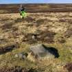
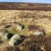
NT 6183 6519. The Crow Stones: name verified. The remains of a circular stone setting is situated at approximately 305m OD on a level terrace above Kingside Burn. Although the S and E arcs are poorly defined, it appears on plan that the setting was oval, measuring approximately 43.0m NW-SE by 33.0m NE-SW. On the N and W is a clear though intermittent arc of mainly small earthfast stones averaging 0.3m high, with seven possible socket holes and two large recumbent blocks up to 0.8m wide and 0.6m high. There are only three stones, one dislodged, around the E side, but on plan these do indicate the overall shape.
The only possibly significant internal feature is a vague circular swelling 0.1m high and approximately 4.0m in diameter with a depressed centre, that occurs in the southern half of the circle.
Surveyed at 1/10,000.
Visited by OS (JRL) 30 April 1979
Burl identified the Crow Stones as a rectangular setting of four low stones, 5ft apart diagonally. It may be related to the Four-Posters of central Scotland.
A Thom, A S Thom and A Burl 1980
Field Visit (23 May 1913)
The site was visited by RCAHMS archaeologist J G Callander on 23 May 1913. He noted the site as ‘a setting of [?unshapely] boulders of small size placed in [the] form of a circle 43 by 40 paces, only one stone about 1 foot 9 inches in height rises more than 1 foot above ground. On the south side there is a setting [of four stones]’. The site was not included in the resultant East Lothian County Inventory (RCAHMS 1924), perhaps because of a question mark over its date.
Note (6 January 2020)
The location, classification and period of this site have been reviewed.

