
Pricing Change
New pricing for orders of material from this site will come into place shortly. Charges for supply of digital images, digitisation on demand, prints and licensing will be altered.
Blackcastle Rings


Promontory Fort (Prehistoric), Rig And Furrow (Medieval) - (Post Medieval)
Site Name Blackcastle Rings
Classification Promontory Fort (Prehistoric), Rig And Furrow (Medieval) - (Post Medieval)
Canmore ID 57300
Site Number NT64NE 5
NGR NT 6935 4785
Datum OSGB36 - NGR
Permalink http://canmore.org.uk/site/57300


- Council Scottish Borders, The
- Parish Greenlaw
- Former Region Borders
- Former District Berwickshire
- Former County Berwickshire
NT64NE 5 6935 4785.
(NT 6935 4785) Blackcastle Rings (NR)
OS 6"map, (1957).
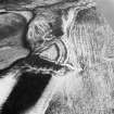
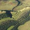
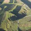
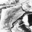
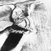
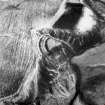
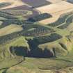
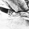
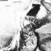
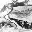
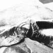
'Blackcastle Rings': This promontory fort is situated above the left bank of the Blackadder Water, a short distance below its junction with the Fangrist Burn, at a height of 679ft OD. Two earthen ramparts, accompanied by external ditches, cut off a steep-sided, V-shaped promontory (see plan RCAHMS 1915); the broad end of the interior measures about 220ft, and the sides somewhat less. The inner rampart measures some 6ft high internally, while its associated ditch is at most some 14ft deep and 34ft wide. The second rampart, 35ft away, is 3ft high internally, and its ditch, which has a low mound on the counterscarp, is some 28 to 30ft wide. The entrance may have been at the N end of the ramparts, where the outer rampart turns slightly outwards.
RCAHMS 1915, visited 1908.
This monument, classified as an earthwork by both the OS and Society of Antiquities field surveyors, is still generally as described by the RCAHMS. The enclosed area (given as 45m in length by 63m in maximum breadth - RCAHMS 1980) has decreased very little since the 1908 plan, erosion having apparently been slower than the bare banks would suggest (OS field surveyor {CJP} visited 1 October 1956).
Revised at 1/2500.
Visited by OS(RDL) 22 August 1963.
RCAHMS 1980, visited 1979.
The New Statistical Account, followed by the Ordnance Survey Name Book (ONB) and Wilson, states that a piece of a silver chain was found within Blackcastle Rings. However, Smith (J A Smith 1875), quoting a description of the find, states that it was found nearby, in what was then identified as Herrit's Dyke (Lin 531). (However, this could be an allusion to the Black Dyke described on NT64NE 6, and it should be noted that natural features adjacent to and running N of Blackcastle Rings were considered to be part of this work.) It was so oxidised that it was given to the blacksmith at Greenlaw, who was intending to use it to repair the chain of a cart harness (its identification by authorities 8-12 as comparable with massive Pictish chains has derived from this circumstance) when its true nature was discovered and it was sent to Lord Marchmont, who died in 1794. The chain is now lost. (The illustration given in Proc Soc Antiq Scot 73 is erroneous.)
New Statistical Account (NSA, A Home written 1834) 1845; Name Book 1857; D Wilson 1863; W Elliot 1872; Lord Dunglas and J A Smith 1881; A J H Edwards 1939; R B K Stevenson 1956.
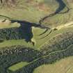
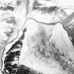
The Blackcastle Rings are visible on a vertical air photograph (OS 70/364/006, flown 1970).
Information form RCAHMS, 1997
Field Visit (7 October 1908)
171. Promontory Fort,’Blackcastle Rings’.
This fort (fig. 90) is situated 1 ¾ miles north-west of Greenlaw (by Greenlaw Dean), above the left bank of the Blackadder, a short ‘distance below its junction with the Fangrist Burn, and 679 feet above sea-level. The enclosure occupies the summit of an angular spit, and is formed by two concentric curved lines of defence drawn across its base, consisting of (a) an inner rampart some 6 feet high to the inside, (b) a trench at most some 14 feet deep and 34 feet across, (c) a level space 35 feet broad, (d) a second rampart 3 feet high on the inner side and 6 to 7 feet on the outside, and (e) a ditch some 28 to 30 feet across, with a low mound on the top of the counterscarp. A slight outward curve of the outer rampart at the north end may indicate the position of the entrance at that spot. The ramparts are apparently of earth. The broad end of the interior measures about 220 feet, and the sides somewhat less. A short distance out from the north end of the defences a track leads down a slope towards the junction of the Blackadder with the Fangrist Burn.
See Antiquaries, xxix. p. 148 (plan and secs.); An Old Berwickshire Town (Gibson), p. 250; Christison, p. 133.
RCAHMS 1915, visited 7th October 1908.
OS Map: Ber, xxi. NE.
Note (25 January 2016 - 21 October 2016)
A small fort is situated on a promontory formed where a gully known as Deil's Neuk cuts through the escarpment on the E side of the Blackadder Water gorge NW of Greenlaw. Triangular on plan, it measures internally 45m in length from NE to SW by a maximum of 63m transversely (0.18ha) immediately to the rear of the defences. These comprise two widely-spaced ramparts with external ditches drawn in an arc across the NE approaches, though whether they are contemporary is not known. The inner rampart still stands some 2m high internally and its ditch is up to 5.8m in breadth by 1.2m in depth, apparently dug in three straight segments; the outer rampart lies some 10m outside the inner ditch and is rather slighter, standing only 1m high, but its ditch is up to 5.9m in breadth by 0.8m in depth and is flanked by a traces of counterscarp bank; it encloses an overall area of 0.38ha. The position of the entrance is unknown and at both ends the ramparts and ditches terminate on the margins of the promontory, though on the N the ditch of the outer turns slightly outwards and disappears in the top of a gully running down the slope. The interior has been cultivated in ridges and is otherwise featureless. Outside the defences an old trackway terrace drops down the face of the escarpment into the gorge, presumably making for a ford at the confluence of the Blackadder Water and the Fangrist Burn.
Information from An Atlas of Hillforts of Great Britain and Ireland – 21 October 2016. Atlas of Hillforts SC4029
Sbc Note
Visibility: This is an upstanding earthwork or monument.
Information from Scottish Borders Council

