
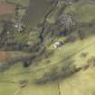
Crailing House, West Lodge


Gate Lodge (Period Unassigned)
Site Name Crailing House, West Lodge
Classification Gate Lodge (Period Unassigned)
Canmore ID 134210
Site Number NT62SE 60.01
NGR NT 68738 24602
Datum OSGB36 - NGR
Permalink http://canmore.org.uk/site/134210


- Council Scottish Borders, The
- Parish Crailing
- Former Region Borders
- Former District Roxburgh
- Former County Roxburghshire
NT62SE 60.01 68738 24602
Crailing House, West Lodge is visible on vertical air phtographs (OS 68/008, 085 and 123, flown 1968), and also depicted with annotation on the current chart copy of the OS 1:10000 map, (1974).
Information from RCAHMS, September 1994
Sbc Note
Visibility: This is an upstanding building.
Information from Scottish Borders Council.

