
Crag Wood


Fort (Period Unassigned)
Site Name Crag Wood
Classification Fort (Period Unassigned)
Canmore ID 56960
Site Number NT62NE 3
NGR NT 6578 2621
Datum OSGB36 - NGR
Permalink http://canmore.org.uk/site/56960


- Council Scottish Borders, The
- Parish Crailing
- Former Region Borders
- Former District Roxburgh
- Former County Roxburghshire
NT62NE 3 6578 2621.
(NT 65782621) Fort (OE)
OS 6"map, Roxburghshire, (1923).
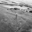
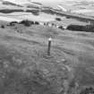
Fort, Crag Wood. This fort (RCAHMS 1956, fig.164), which occupies a rocky knoll at a height of 700ft OD, is situated close to the NW. side of Crag Wood and 300yds E of RCAHMS 1956, no.201. The SE flank of the knoll is steep, while the NW side and SW flanks both terminate in gullies some 50ft wide, the former of which is still marshy in places ; thus the only easy access is from the NE along a gently inclined ridge. The fort is roughly oval on plan and measures internally 330ft from NE to SW by 150ft transversely. Erosion has destroyed all trace of the defences on the SE side, but elsewhere they consist of two walls averaging 35ft apart from crest to crest. Both walls have been heavily robbed and for the most part appear simply as crest-lines capped with tumbled stones. No facings are visible. Slight traces of a medial ditch can be seen at the NE and gaps in both walls at this end presumably represent the site of the original entrance. Several faint scoops in the interior, too indefinite to plan, may indicate the position of dwellings.
RCAHMS 1956, visited 3 April 1950.
This fort is generally as described above. The medial ditch can be seen at the SW end as well as at the NE.
Revised at 1/2500.
Visited by OS(RDL) 5 December 1963.
Note (1 September 2015 - 24 May 2016)
This fort occupies a steep-sided hillock forming one of the summits on a lower shoulder of the upper slopes of Peniel Heugh. Oval on plan, it measures internally about 100m from NE to SW by 45m transversely (0.35ha). The defences comprise twin ramparts with a medial ditch, which can be traced round the margins of the hillock everywhere except the SE, where the ground falls away steeply at the top of a long slope down to the N bank of the River Teviot at Nisbet; the ramparts, however, have been reduced to little more than scarps and the medial ditch is visible only on the NE and SW. The entrance is probably on the NE, approaching along the crest of the slope dropping away to the SE. In 1950 several shallow scoops marking the probable positions of timber round-houses were noted by RCAHMS investigators.
Information from An Atlas of Hillforts of Great Britain and Ireland – 24 May 2016. Atlas of Hillforts SC3377
Sbc Note
Visibility: This is an upstanding earthwork or monument.
Information from Scottish Borders Council

