
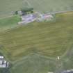
Tantallon, Gin Head, Chain Home Low Station


Radar Station (20th Century)
Site Name Tantallon, Gin Head, Chain Home Low Station
Classification Radar Station (20th Century)
Canmore ID 320136
Site Number NT58NE 58.01
NGR NT 59050 85310
Datum OSGB36 - NGR
Permalink http://canmore.org.uk/site/320136

- Council East Lothian
- Parish North Berwick
- Former Region Lothian
- Former District East Lothian
- Former County East Lothian
External Reference (June 2012)
Gin Head radar station was a World War II radar station located on Gin Head to the east of North Berwick on the south shore of the Firth of Forth. Designation: M27 Gin Head.
Information from the UK Pillbox Study Group, June 2012

